#erosion risk and mapping.
Text
AI increases what historian and philosopher Hannah Arendt called “institutional thoughtlessness” – the inability to critique instructions or reflect on consequences. Its objective devaluations interface all too readily with existing bureaucratic cruelties, scaling administrative violence in ways that intensify structures of inequality, such as when AI is used to aid decisions about which patients are prioritised in healthcare or which prisoners are at risk of reoffending.
AI also relies on extractive violence because the demand for low-paid workers to label data or massage outputs maps onto colonial relations of power, while its calculations demand eye-watering levels of computation and the consequent carbon emissions, with a minimum baseline for training that is equivalent to planeloads of transatlantic air passengers.
The compulsion to show balance by always referring to AI’s alleged potential for good should be dropped; we must acknowledge that the social benefits are still speculative, but the harms have been empirically demonstrated. We must recognise that this algorithmic violence is legitimised by AI’s claims to reveal a statistical order in the world that is superior in scale and insight to our direct experience. This also constitutes – among other things – a logical fallacy and a misuse of statistics.
Statistics, even Bayesian, does not extrapolate to individuals or future situations in a linear-causal fashion, and completely leaves out outliers. Ported to the sociological settings of everyday life, this results in epistemic injustice, where the subject’s own voice and experience is devalued in relation to the algorithm’s predictive judgements.
While on the face of it AI may seem to produce predictions or emulations, I would argue that its real product is precaritisation and the erosion of social security; that is, AI introduces vulnerability and uncertainty for the rest of us, whether because our job is under threat of being replaced or our benefits application depends on an automated decision. Instead of sci-fi futures, what we get is the return of 19th-century industrial relations and the dissolution of post-war social contracts.
68 notes
·
View notes
Text
The History of Area 59 Ruins
If you're dumb enough to Max Risk CC this weekend, you're a big enough schmuck to come to the Area 59 Ruins.
For now, let's settle with a little mood music while I get started.
So this post is just me kind of rambling nostalgically but with CC12 coming soon I figure we can enjoy the end of our CC journey with the very beginning. Plus this event happened like, at the beginning of this game's lifespan I kind of doubt most of the current Arknights players remember doing it.

These days you can only experience this map in the Training Grounds, which is a bit of a shame that it hasn't rotated back in. The gist of the stage is this: from the bottom left entrances come Light-Armored Soldiers, Heavy Defenders, and Armed Militants. From the upper left come Avengers, Hateful Avenger, and one Invisible Caster Leader I call The Rat Bastard because he sucks. From the bottom right, only Invisible Caster Leaders spawn.
There's no bosses and all of the enemies primarily just have their stats (and the Caster's Camo) to threaten you with. If you look at the contracts available...
Originium Zone: Activation III - Enemies have their HP increased by 2.5x. (3 points)
Originium Zone: Stimulus III - Enemies have their ATK increased by 1.8x. (3 points)
Objective: Blade Breaker III - Avengers and Hateful Avengers have their HP, ATK, and DEF increased by 2.2x, 1.8x, and 3x, respectively (3 points)
Objective: Armament Destruction III: Armed Militants have their HP, ATK, RES, and weight increased by 2.5x, 1.8x, 1.75 and 2, respectively. (3 points)
Objective: Covert Action III: Only 4 Operators (including the Support Unit) can be included to the squad. (3 points)
Objective: Strategic Dispatch: Casters and Medics cannot be used. (2 points)
Objective: Deep Infiltration: DP generation rate reduced by 50% (1 DP every 2 seconds). (2 points)
Environment: Precipituous Terrain III: Friendles cannot be deploying in 10 tiles (3 points)
Anti-Armor I: Enemies have their DEF increased by 50% (1 point)
Anti-Sniper I: Ranged enemies have their attack range increased by 50%. (1 point)
Anti-Mobility I: Enemies have their speed increased by 50%. (1 point)
Objective: Last Line of Defense: Life Point reduced to 1. (1 point)
Originium Zone: Erosion III: Friendlies have their maximum HP reduced by 75%. (3 points).
There might be a couple that jump out at you (we'll get to that in a minute) but total max risk was 29 and most of these are pretty simple in their execution. What was the Max Risk that was achieved by players?
To the best of my knowledge, the Max Risk achieved was 26. Which is kind of wild to think about. In this day and age it seems like almost a guarantee that a CC will get a Max Risk clear super quickly, and there are some truly heinous clears like that Ashpoint All Specialist clear. So how...did this happen?
Well there's two reasons really. The first is actually really simple: as of CC Beta's release, the most recently released operator was Mostima. This meant in terms of meta-breaking 6-stars, you had: Ch'en, Siege, Shining, Nightingale, Ifrit, Eyjafjalla, Exusiai, Angelina, Silverash, Hoshiguma, Saria, Skadi, Schwarz, Hellagur, Magallan, and Mostima. There's a lot of good operators there, but most people would agree that the grand majority of them aren't what we think of when it comes CC all-stars.
The second is how the stage is set-up. With all the tags enabled, let's look at the stats of two enemies in particular: the Hateful Avenger

and the Armed Militant

(HP, ATK, DEF, RES, Movement Speed in tiles/sec, Weight, and Attack Range)
Now despite that gigantic 99,000 HP, the Hateful Avengers were not really a big problem. They can actually be Push stalled basically endlessly. They'll take a while to actually die but it's not particularly hard to just whittle them down.
The Armed Militants are the problem. Their 5 Weight means they are very difficult to stall with shifting and thanks to the Erosion contract, nothing survives their axe swings. So already the map has two lanes you need to hold.
But it actually has a secret, THIRD LANE.

These guys are also nightmares and need to be dealt with basically immediately. Their 720 damage Arts attacks are much more lethal with -75% HP, but their increased attack range makes them a bigger issue. With the tag, they have an Attack Range of 3 tiles, but this is a little deceptive in how its framed. Let me illustrate.
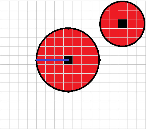
Attack ranges are essentially circles, with a radius of the attack range distance in tiles. This means they can hit some tiles you might immediately think are actually four tiles away and not three.

The difference in attack ranges means that the Caster Leaders will often have complete free reign from their starting position to blast away at your entire bottom line if left unchecked, which is very bad. This isn't even getting into the one that spawns at the top too.
(Ignore the quality of these diagrams, I did them in Paint.)
So you have three lanes to defend, that's not hard, right?
Objective: Covert Action III: Only 4 Operators (including the Support Unit) can be included to the squad.
This. This is the bastard. To this day, I don't believe they've ever done a similarly restrictive squad condition in a main map (its possibly been in a rotating one, there's been 12 CCs I'm not checking).
The Risk 26 clear takes the 2 risk HP increase contract (which only boosts HP by 1.6x) and the 1 risk Squad contract (maximum of 10). With the current pool of obviously busted operators, I think it would be really easy to take the Risk 3 HP increase contract and the Risk 2 squad contract. Risk 28 is obvious. But trimming the squad down to four operators is a much more monumental task. I don't know if I would say impossible, but very very difficult.
Area 59 Ruins also ran on the rotating schedule for two CCs (CC0 Barrenlands and CC1 Pyrite) and I'll include them later on as their existence as rotating stages is far less interesting and I'm making this post while recovering from a virus lmao.
15 notes
·
View notes
Text
Cities on the São Paulo Coast Have 25,000 Properties in Risk Areas
The survey combined data from the 2022 Demographic Census with mapping from the Brazilian Geological Survey

In 2022, the Baixada Santista and the northern coast of São Paulo had at least 25,481 residential addresses in risk areas, nearly half of them classified as "high risk." The data were obtained by cross-referencing the geographic coordinates from the 2022 Demographic Census by IBGE (Brazilian Institute of Geography and Statistics) and a mapping of landslide susceptibility done by the Brazilian Geological Survey (formerly CPRM). Buildings in these addresses are exposed to natural disasters and face risks of collapses and floods. In the case of the coast, a large portion of the properties was built on mountain slopes, flood-prone areas, or coastal erosion areas—a process in which the beach loses its sediments.
Continue reading.
#brazil#brazilian politics#politics#environmental justice#housing#mod nise da silveira#image description in alt
3 notes
·
View notes
Text
Elevating Your GIS Projects with Precise Digital Terrain Models
Welcome to Satpalda, your premier destination for cutting-edge solutions in Geographic Information Systems (GIS) and remote sensing technology. With our expertise and commitment to excellence, we empower professionals across industries to leverage the power of accurate spatial data for informed decision-making and transformative projects.
At Satpalda, we understand the paramount importance of precise terrain modeling in GIS applications. Whether you're planning infrastructure projects, conducting environmental assessments, or optimizing resource management, a reliable Digital Terrain Model (DTM) forms the cornerstone of your spatial analysis. Let's delve into how DTM in GIS and terrain modeling solutions can revolutionize your workflows and unlock new possibilities for your projects.
Understanding Digital Terrain Models (DTM) A Digital Terrain Model (DTM) represents the bare-earth surface without any features such as buildings, vegetation, or infrastructure. It provides a detailed three-dimensional representation of the Earth's surface, depicting variations in elevation with high accuracy. DTM in GIS serves as the foundation for a wide range of applications, including flood risk assessment, land-use planning, and telecommunications network planning.
Benefits of Terrain Modeling in GIS
Precision in Analysis: Terrain modeling allows for precise spatial analysis by capturing subtle changes in elevation. This precision is invaluable for assessing slope stability, calculating drainage patterns, and identifying suitable locations for infrastructure development.
Enhanced Visualization: By integrating DTM into GIS platforms, users can visualize terrain features in stunning detail. This enhanced visualization aids in communicating spatial information effectively and gaining insights into topographic characteristics.
Accurate Volume Calculations: Terrain modeling facilitates accurate volume calculations for earthwork projects, mining operations, and landfills. By quantifying cut and fill volumes with precision, stakeholders can optimize project timelines and resource allocation.
Improved Decision-making: In fields such as urban planning and environmental management, terrain modeling enables informed decision-making. By analyzing terrain attributes such as slope, aspect, and curvature, stakeholders can assess the suitability of land for various purposes and mitigate potential risks.
Seamless Integration: DTM seamlessly integrates with other GIS datasets, such as aerial imagery, LiDAR point clouds, and satellite imagery. This integration enhances the richness of spatial analysis and enables comprehensive understanding of geographical phenomena.
Applications of DTM in GIS
Hydrological Modeling: DTM forms the basis for hydrological modeling by delineating watershed boundaries, identifying flow paths, and estimating runoff volumes. These capabilities are essential for water resource management, flood forecasting, and erosion control.
Transportation Planning: In transportation planning, DTM aids in route optimization, site selection for infrastructure development, and assessing terrain suitability for road construction. By considering elevation data, planners can minimize construction costs and environmental impact.
Natural Resource Management: DTM supports natural resource management initiatives by mapping terrain features relevant to forestry, agriculture, and conservation. From assessing terrain ruggedness to identifying potential habitat corridors, terrain modeling informs sustainable resource utilization practices.
Disaster Risk Management: Terrain modeling plays a critical role in disaster risk management by identifying areas prone to natural hazards such as landslides, floods, and wildfires. By conducting hazard mapping and vulnerability assessments, stakeholders can prioritize mitigation efforts and enhance community resilience.
Our Terrain Modeling Solutions At Satpalda, we offer comprehensive terrain modeling solutions tailored to your project requirements. Leveraging advanced GIS techniques and state-of-the-art technology, we deliver highly accurate Digital Terrain Models that empower you to make informed decisions and achieve your project objectives. Our services include:
DTM Generation: We utilize cutting-edge remote sensing data, including LiDAR and high-resolution satellite imagery, to generate precise Digital Terrain Models tailored to your project specifications.
Terrain Analysis: Our GIS experts conduct thorough terrain analysis, extracting valuable insights such as slope characteristics, elevation profiles, and drainage patterns to support your decision-making process.
Customized Solutions: We understand that every project is unique. That's why we offer customized terrain modeling solutions designed to address your specific challenges and maximize the value of spatial data.
Established with a vision to revolutionize the satellite imagery industry, Satpalda brings together a team of seasoned professionals with extensive expertise in remote sensing, geospatial analysis, and satellite technology. Our commitment to excellence and innovation drives us to constantly push the boundaries, ensuring that our clients receive the highest quality products and services available.
Our Products
One of our flagship offerings is KOMPSAT imagery, which stands at the forefront of remote sensing technology. KOMPSAT satellites, including KOMPSAT 3 and KOMPSAT 3A, are renowned for their exceptional resolution, accuracy, and reliability. Whether you're in need of high-resolution optical imagery for urban planning, agriculture monitoring, environmental analysis, or disaster management, our KOMPSAT products deliver unmatched clarity and detail.
Why Choose KOMPSAT Imagery?
Superior Quality: KOMPSAT satellites are equipped with state-of-the-art sensors capable of capturing imagery with stunning clarity and precision, ensuring that you receive the highest quality data for your projects.
Global Coverage: With regular revisit times and extensive coverage areas, KOMPSAT satellites provide comprehensive coverage of both urban and rural areas across the globe, allowing you to monitor changes and trends with ease.
Reliability: Backed by the latest advancements in satellite technology and a track record of reliability, KOMPSAT imagery offers peace of mind, knowing that you can depend on accurate and up-to-date information for your decision-making processes.
Our Services
In addition to our extensive range of satellite imagery products, we offer a variety of value-added services to enhance the utility and usability of your data. From image processing and analysis to custom solutions tailored to your specific requirements, our team of experts is dedicated to delivering results that exceed your expectations.
Customer Satisfaction
At Satpalda, we prioritize customer satisfaction above all else. We understand that each project is unique, and we work closely with our clients to ensure that their needs are met with precision and efficiency. Whether you're a government agency, academic institution, or private enterprise, you can trust Satpalda to deliver the solutions you need to succeed.
Get in Touch
Ready to harness the power of KOMPSAT imagery for your next project? Contact us today to learn more about our products and services, or to discuss how we can tailor a solution to meet your specific needs. With Satpalda as your trusted partner, the possibilities are endless.
For More Info:-
digital elevation model in gis
DEM in GIS
DTM
DTM in GIS
terrain modelling in gis
digital terrain model
digital elevation model in gis
digital elevation models
KOMPSAT imagery
KOMPSAT 3 imagery
KOMPSAT 3A imagery
GIS Services
gis 3d modelling
Digital Mapping
satellite mapping
0 notes
Text
What Role Does Pricing Intelligence Play in Securing a Competitive Advantage in 2024?

Research indicates that price plays a crucial role in consumers' decision-making process, with approximately 80% finding it essential (20%) or significant (60%). It underscores a fundamental reality well-known to businesses: pricing influences purchasing behavior and is essential for maintaining a competitive edge in 2024. The price remains constant throughout the various stages of the buying journey, while other factors may fluctuate. If a product is priced too high, the risk of losing a substantial portion of potential sales looms large. Conversely, setting the price too low can lead to profit erosion for the company. Hence, in today's competitive landscape, striking the optimal balance between value and profitability is imperative for businesses to maintain their competitive edge. More than simply observing competitors' pricing strategies is required for devising an effective pricing strategy. Employing cutting-edge technologies such as intelligent pricing is essential for informed decision-making and sustained success.
Know About Pricing Intelligence
In simpler terms, "price intelligence" involves making smart decisions about pricing. This involves analyzing data from competitors and similar products, as well as considering market trends and consumer behavior. By leveraging this information, businesses can adjust their prices strategically to stay competitive. Essentially, pricing intelligence is like crafting a pricing strategy informed by real-time market insights.
One crucial tool in executing pricing intelligence is E-Commerce Web Scraping. It involves using specialized software to extract relevant pricing data from various online sources. By harnessing AI and data mining tools, businesses can gather valuable information about competitor prices, sales, discount codes, and more. This data then informs their pricing decisions, helping them stay agile and responsive in a dynamic market landscape.
Now, let's delve into why pricing intelligence is so important, especially when coupled with E-Commerce Web Scraping.
Significance of Pricing Intelligence
Understanding the significance of competitive pricing is crucial for businesses navigating competitive markets. By leveraging competitive price intelligence and competitor price monitoring, companies can optimize pricing strategies to enhance profitability and maintain competitiveness.
Staying Competitive with Competitive Price Intelligence: Competitive price intelligence is crucial for businesses looking to stay ahead. Companies can adjust their prices to remain competitive by monitoring competitors' pricing strategies. It involves gathering data on competitor pricing trends, identifying price gaps, and strategically positioning their prices to attract customers. Without this insight, businesses risk losing customers to competitors offering better deals.
Optimizing Profit Margins: Pricing intelligence enables businesses to optimize their profit margins by finding the right balance between pricing and demand. By analyzing market trends and consumer behavior, companies can identify price points that maximize revenue while still attracting customers. It helps businesses refrain from underpricing products, leaving money on the table, and overpricing and driving customers away.
Effective Competitor Price Monitoring: Pricing intelligence tools facilitate competitor price monitoring, allowing businesses to track real-time pricing changes. This information is invaluable for adjusting pricing strategies on the fly to maintain competitiveness. Businesses can continuously monitor competitor prices, identify pricing trends, understand market dynamics, and make informed pricing decisions accordingly.
Enhancing Customer Loyalty: Pricing intelligence, including MAP monitoring, helps businesses understand customers' price sensitivity and preferences. Companies can attract and retain customers by offering competitive prices and timely discounts, fostering loyalty in a highly competitive market. Additionally, by ensuring pricing consistency across channels and adhering to MAP policies, businesses build customer trust, further strengthening loyalty. MAP monitoring ensures that prices are maintained at or above a certain threshold, safeguarding brand reputation and customer trust while fostering long-term relationships.
Optimizing Inventory Management: Pricing intelligence is critical in inventory management. By analyzing pricing trends and demand patterns, businesses can make informed decisions about inventory levels, pricing promotions, and product bundling. This helps prevent stockouts and overstock situations, minimize inventory holding costs, and maximize profitability.
Adapting to Market Dynamics: In today's fast-paced market environment, pricing intelligence enables businesses to adapt quickly to changing market dynamics. Companies can make agile pricing adjustments by continuously monitoring competitor prices, consumer behavior, and market trends to capitalize on opportunities and mitigate risks. This flexibility is essential for staying competitive and maintaining profitability in dynamic markets.
Thus, pricing intelligence, mainly through competitive price intelligence and competitor price monitoring, is indispensable for businesses seeking to optimize profit margins, enhance customer loyalty, and adapt to evolving market dynamics. By leveraging pricing data and insights, businesses can make informed pricing decisions that drive growth and success in an increasingly competitive landscape.
Tips to Gather Price Intelligence
Collecting pricing intelligence involves gathering and analyzing data from various sources to inform pricing decisions. Here are some tips to effectively gather pricing intelligence while aligning with your pricing strategies:
Utilize Web Scraping Tools: Invest in web scraping tools or services to automatically extract pricing data from competitor websites, marketplaces, and other online sources. These tools can help gather large volumes of data efficiently, supporting your pricing strategies.
Monitor Competitor Websites: Regularly visit competitors to observe pricing changes, promotions, and discounts manually. Take note of any pricing strategies or patterns that may influence your pricing decisions and align with your pricing strategies.
Leverage Price Comparison Websites: Use price comparison websites and platforms to compare your prices with competitors in real-time. These platforms provide valuable insights into how your prices compare to others in the market and can inform your pricing strategies accordingly.
Monitor Social Media and Forums: Monitor social media channels and online forums where customers discuss pricing and promotions. Look for mentions of competitors' prices, discounts, and customer experiences to gauge market sentiment and adjust your pricing strategies as needed.
Analyze Historical Pricing Data: Review historical pricing data to identify trends, seasonality, and patterns in pricing behavior. This information can help predict future pricing trends and inform pricing strategies that are aligned with your business objectives.
Conduct Mystery Shopping: Engage in mystery or undercover shopping to assess competitor pricing and customer service firsthand. This approach provides valuable insights into competitor pricing strategies and customer experiences, aiding in refining your pricing strategies.
Attend Industry Events and Conferences: Participate in industry events and conferences to network with peers and gather insights into pricing trends, best practices, and emerging technologies in your sector. This knowledge can inform your pricing strategies and keep you competitive.
Utilize Price Tracking Tools: Explore price tracking tools and software that monitor competitor prices and alert you to any changes or fluctuations. These tools automate gathering pricing intelligence, support your pricing strategies, and help you make timely adjustments when necessary.
Monitor Advertising and Promotions: Track competitors' advertising campaigns, promotions, and discounts across various channels, including print, digital, and social media. Analyze these strategies' effectiveness and impact on pricing to refine your pricing strategies accordingly.
Stay Informed About Regulatory Changes: Stay updated on regulatory changes, tariffs, and industry regulations that may impact pricing decisions. Consider how these factors could affect your pricing strategy and adjust accordingly to maintain compliance and competitiveness.
By implementing these tips while considering your pricing strategies, businesses can gather comprehensive pricing intelligence to make informed pricing decisions and stay competitive.
Conclusion
In 2024, pricing intelligence will emerge as a critical tool for businesses striving to gain a competitive edge in dynamic markets. Understanding customers' price sensitivity and preferences through data-driven insights allows companies to tailor their pricing strategies effectively. By leveraging competitive prices and strategic discounts, businesses attract and retain customers, fostering loyalty amidst intense market competition. Moreover, maintaining pricing consistency across channels and adhering to MAP monitoring ensures trust and credibility, reinforcing brand reputation. In essence, pricing intelligence becomes indispensable in navigating the complexities of the market landscape, empowering businesses to stay agile, responsive, and ahead of the curve in 2024.
Leverage the power of data-driven decisions with our Retail Scrape Company. Utilize consumer behavior insights, fine-tune pricing strategies, and surge ahead of competitors with real-time retail data scraping. Elevate your business with our comprehensive pricing optimization solutions and strategic decision support. Reach out today to revolutionize your retail ventures and maximize profits!
know more :
https://www.retailscrape.com/pricing-intelligence-role-in-competitive-advantage.php
#pricingintelligence2024#CompetitiveAdvantagein2024#PricingIntelligence#CompetitivePricing#CompetitivePriceIntelligence#PriceMonitoring#ECommerce Web Scraping
0 notes
Text
Land Clearing 101
If you have land that is overgrown with brush, weeds, and other vegetation, clearing it can be beneficial. It will allow the grass, trees and other plants to have more access to water and sunlight, allowing them to grow and thrive. It can also help with soil erosion, which is a big problem in some areas. Clearing can be done on residential or commercial property, and there are several different ways to do it.
One way is to use machinery, such as bulldozers or excavators. This is typically the fastest method, but it can cause significant damage to the soil and is not ideal for sensitive areas, such as steep slopes or fragile ecosystems. Another option is to use herbicides, which are chemicals that kill the vegetation. While they are effective, they can be harmful to the environment and may affect other plants and animals. Finally, manual removal is a time-consuming but precise method that allows for more selective clearance.
The best time to do land clearing is in the late fall or spring, when the plants are dormant. This will minimize the risk of poison oak and other noxious plants. It will also be easier to see where you’re working, so there is less risk of injury.
Before beginning the clearing process, you should consult your local land planning agency to determine if a permit is required. If it is, you’ll need to provide specific details about the site and what you’ll be doing with it. You may also need to submit other documents or information, such as a survey or map of the site and any environmental assessments or studies.
Once the clearing process is complete, the land should be inspected to ensure that there are no hazards. For example, dead limbs from trees can pose a fire hazard and are also a nuisance for passersby. They can also harbor airborne viruses that could affect the health of nearby people or animals. Clearing, along with regular maintenance, can prevent these problems.
In addition to removing invasive species, weeds and brush, clearing can also be used for agriculture. The clearing process will remove any accumulated vegetation that is taking up too much space and preventing crops from getting the nutrients they need to thrive. This is particularly important in fields where a lot of the land is covered with bushes and other plants that can compete for resources with crops. In these cases, clearing can be a lifesaver.
via https://ontimetreelopping.wordpress.com/2024/04/08/land-clearing-101/
0 notes
Text
0 notes
Text
Understanding the Benefits and Risks of Reverse Mortgage Service

Reverse mortgage services offer a unique financial solution for homeowners, especially seniors, looking to tap into their home equity without selling their property. However, like any financial product, reverse mortgages come with both benefits and risks. This article aims to provide a comprehensive understanding of the advantages and disadvantages of reverse mortgage services.
Understanding Reverse Mortgages
Reverse mortgages allow homeowners aged 62 or older to convert a portion of their home equity into cash while retaining ownership of the property.
Unlike traditional mortgages, borrowers do not make monthly mortgage payments. Instead, the loan balance accumulates over time and is typically repaid when the borrower sells the home, moves out, or passes away.
Reverse mortgage loans are insured by the Federal Housing Administration (FHA) and subject to specific eligibility requirements and loan limits.
Benefits of Reverse Mortgage Services
Supplement Retirement Income: Reverse mortgages provide a source of tax-free income for retirees, allowing them to enhance their financial security and maintain their lifestyle.
No Monthly Payments: Borrowers are not required to make monthly mortgage payments, alleviating financial strain and providing flexibility in budgeting.
Stay in Your Home: Reverse mortgages enable homeowners to stay in their homes for as long as they wish, as long as they fulfill loan obligations such as property taxes and insurance.
Flexible Disbursement Options: Borrowers can receive funds in various ways, including a lump sum, monthly payments, line of credit, or a combination of these options, tailored to their needs.
Risks and Considerations
Accumulating Loan Balance: Since no monthly payments are required, the loan balance grows over time with accrued interest, potentially reducing the equity remaining in the home.
Impact on Heirs: Upon the borrower's death, heirs may inherit the property subject to repaying the reverse mortgage balance, which could limit their inheritance.
Costs and Fees: Reverse mortgages may entail upfront costs such as origination fees, closing costs, and mortgage insurance premiums, which can affect overall loan affordability.
Home Equity Erosion: Depending on loan terms and market conditions, the equity in the home may diminish over time, impacting future financial planning and housing options.
Eligibility and Qualifications
Age Requirement: Borrowers must be at least 62 years old to qualify for a reverse mortgage.
Homeownership Status: The property must be the borrower's primary residence and meet specific eligibility criteria, including property type and condition.
Financial Assessment: Lenders evaluate borrowers' income, credit history, and debt obligations to determine loan eligibility and suitability.
Counseling and Education
FHA mandates that prospective reverse mortgage applicants undergo counseling from HUD-approved counselors to ensure they understand the loan terms, risks, and alternatives.
Counseling sessions provide borrowers with an opportunity to ask questions, assess their financial situation, and make informed decisions about reverse mortgage services.
Summary
Reverse mortgage services offer a valuable financial tool for homeowners seeking to leverage their home equity in retirement. While these loans provide benefits such as supplemental income and flexibility, borrowers must carefully weigh the risks and considerations, including potential equity erosion and impact on heirs. By understanding the pros and cons of reverse mortgages and seeking guidance from qualified counselors, homeowners can make informed decisions that align with their long-term financial goals and housing needs.
Contact us,
Name: A and N Mortgage Services, Inc.
Address: 1945 N Elston Ave, Chicago, IL60642
Phone: (773) 305–5626
Map: https://maps.app.goo.gl/5v2R3EgZHUTr9fJA8
0 notes
Text
Elevating Perspectives: The Benefits of Aerial Drone Photography
In recent years, aerial drone photography has emerged as a powerful tool for capturing stunning images and videos from unique vantage points. Whether used for real estate marketing, landscape photography, filmmaking, or surveying, aerial drones offer unparalleled perspectives that were once only possible with costly equipment and resources. Let's explore the numerous advantages of aerial drone photography and how it is revolutionizing visual storytelling across various industries.
Captivating Perspectives: Aerial drone photography provides captivating perspectives that ground-level photography simply can't match. From sweeping landscapes and architectural masterpieces to dynamic cityscapes and natural wonders, drones offer a bird's-eye view that adds depth, scale,Ariel drone photography and visual interest to images and videos, captivating viewers and creating memorable experiences.
Versatility and Adaptability: Aerial drones are versatile tools that can adapt to a wide range of applications and environments. Whether navigating through rugged terrain, soaring above urban skyscrapers, or capturing footage in remote wilderness areas, drones offer flexibility and agility that traditional aircraft and equipment lack, making them indispensable for photographers, filmmakers, and surveyors alike.
Cost-Effective Solution: Compared to traditional aerial photography methods, such as helicopters or airplanes, aerial drones offer a cost-effective solution for capturing stunning aerial imagery. Drones are more affordable to operate and maintain, require less logistical planning, and can be deployed quickly and easily, making high-quality aerial photography accessible to a wider range of projects and budgets.
Safety and Accessibility: Aerial drones provide a safer and more accessible alternative to manned aerial photography. With drones, photographers and filmmakers can capture aerial footage without putting themselves or others at risk, eliminating the need for expensive helicopter rentals or risky climbs to elevated vantage points. Drones also offer access to hard-to-reach or hazardous areas, such as construction sites, disaster zones, and remote landscapes, allowing for safer and more comprehensive documentation.
Precision and Control: Aerial drones offer precise control over camera positioning, angles, and movements, allowing photographers and filmmakers to capture the perfect shot with ease. With advanced stabilization technology and intelligent flight modes, drones can maintain steady flight paths,drone inspections capture smooth cinematic movements, and execute complex maneuvers, resulting in professional-quality imagery and footage that meets the highest standards.
Environmental Monitoring and Conservation: Aerial drones play a vital role in environmental monitoring, conservation, and research efforts. From tracking wildlife populations and monitoring habitat changes to surveying deforestation and mapping coastal erosion, drones provide valuable data and insights that inform conservation initiatives and support sustainable land management practices.
Innovation and Creativity: Aerial drone photography fuels innovation and creativity in visual storytelling, pushing the boundaries of what's possible in photography and filmmaking. With their compact size, agility, and advanced imaging capabilities, drones inspire photographers and filmmakers to experiment with new perspectives, compositions, and storytelling techniques, resulting in groundbreaking imagery and immersive experiences for audiences worldwide.
Conclusion: Aerial drone photography offers a multitude of benefits, from captivating perspectives and cost-effective solutions to safety, precision, and environmental monitoring. As technology continues to evolve and drones become increasingly accessible and sophisticated, their potential for revolutionizing visual storytelling across various industries is limitless. Whether capturing stunning landscapes, documenting construction projects, or supporting environmental conservation efforts, aerial drones are empowering photographers, filmmakers, and researchers to push the boundaries of creativity and innovation in the pursuit of breathtaking imagery and compelling storytelling.
1 note
·
View note
Text
Innovative Solutions for Pond Maintenance: A Focus on Technology
Introduction
Advancements in technology have revolutionized various aspects of pond management, offering innovative solutions for water quality monitoring, vegetation control, and overall maintenance. From automated monitoring systems to drone-based surveys, technological tools are transforming the way ponds are managed and maintained. This article explores some of the latest technological innovations in pond maintenance, highlighting their benefits and applications for pond owners, managers, and environmental professionals.
Automated Water Quality Monitoring Systems
Traditional water quality monitoring methods often require manual sampling and laboratory analysis, which can be time-consuming and labor-intensive. Automated monitoring systems equipped with sensors for measuring parameters such as pH, dissolved oxygen, and temperature offer real-time data collection and analysis, enabling proactive management decisions.
Remote Monitoring and Alert Systems
Remote monitoring systems allow pond managers to access water quality data remotely via mobile devices or computers, providing timely insights into changing conditions and potential issues. Integrated alert systems notify managers of abnormal parameters or trends, allowing for prompt intervention and corrective action.
Drone Technology for Aerial Surveys
Drones equipped with high-resolution cameras and sensors offer a cost-effective and efficient solution for conducting aerial surveys of ponds and surrounding landscapes. From mapping shoreline vegetation to identifying erosion hotspots, drone-based surveys provide valuable data for assessing pond health and planning management strategies.
Vegetation Mapping and Analysis
Using drones to capture aerial imagery enables detailed mapping and analysis of aquatic vegetation within ponds. By monitoring vegetation dynamics over time, managers can identify invasive species, track changes in plant density, and assess the effectiveness of vegetation management efforts.
Robotic Solutions for Vegetation Control
Robotic devices designed specifically for aquatic vegetation control offer precise and targeted treatment options without the need for manual labor or chemical applications. These autonomous systems utilize cutting-edge technology to navigate water bodies and selectively remove or pond management.
Selective Herbicide Application
Robotic herbicide applicators equipped with advanced sensors and software can accurately target specific plant species while minimizing off-target impacts. By delivering herbicides directly to the target plants, these robotic solutions reduce herbicide usage and environmental risks associated with traditional blanket treatments.
Conclusion
Technological innovations are reshaping the landscape of pond maintenance, offering efficient, cost-effective, and environmentally sustainable solutions for water quality monitoring, vegetation control, and overall management. By harnessing the power of automation, remote sensing, and robotics, pond owners and managers can enhance the health, beauty, and functionality of their water bodies while minimizing environmental impact. As technology continues to evolve, the future of pond management looks promising, with new tools and techniques paving the way for more efficient and effective stewardship of these valuable aquatic resources.
1 note
·
View note
Text
The Economic and Environmental Value of Tree Service in Lexington, KY

Lexington, Kentucky, known as the "Horse Capital of the World," is not just famous for its equestrian heritage but also for its abundant tree population. Trees play a vital role in the economic and environmental well-being of this beautiful city. In this blog post, we will explore the significant economic and environmental value that tree service provides to Lexington, KY.
Economic Benefits of Tree Service
Property Value: Trees enhance the aesthetic appeal of residential and commercial properties, making them more attractive to potential buyers. Numerous studies have shown that well-maintained trees can increase property values by as much as 20%. By investing in professional tree services, property owners in Lexington can significantly enhance the value of their real estate assets.
Energy Efficiency: Strategically placed trees around buildings can provide shade during the hot summer months, reducing the need for excessive air conditioning. By acting as natural air conditioners, trees can help property owners lower their energy consumption and utility bills. Tree service professionals can assess the landscape and recommend the best tree species and placement for optimal energy efficiency.
Storm Damage Prevention: Lexington occasionally experiences severe weather conditions, including storms and high winds. Trees that are weak, damaged, or diseased pose a significant risk to nearby structures and power lines during such events. Engaging tree service experts to inspect and maintain trees can help prevent potential damage and associated costs.
Environmental Benefits of Tree Service
Air Quality Improvement: Trees act as natural filters, absorbing carbon dioxide and other pollutants while releasing oxygen. In a city like Lexington, where air quality can be a concern, trees play a crucial role in mitigating pollution and improving overall air quality. Tree service providers help maintain the health and vitality of trees, ensuring their ability to purify the air we breathe.
Urban Heat Island Effect
Urban areas tend to be warmer than surrounding rural areas due to the abundance of concrete and asphalt that absorb and radiate heat. Trees provide natural shade, reducing the urban heat island effect and creating a more comfortable environment for residents and visitors alike. Tree service professionals can assist in selecting and planting the right tree species to maximize the cooling effect.
Erosion Control and Water Management
Trees help prevent soil erosion by stabilizing the ground with their root systems. In addition, they absorb rainwater and reduce runoff, which helps in managing stormwater and reducing the risk of flooding. By maintaining healthy trees and implementing proper tree care practices, tree service providers contribute to effective erosion control and water management in Lexington.
Tree service company in Lexington, KY, offers both economic and environmental benefits that are invaluable to the community. From enhancing property values and energy efficiency to improving air quality and mitigating the urban heat island effect, trees play a vital role in creating a sustainable and thriving city. By partnering with professional tree service providers, property owners can contribute to the preservation and growth of Lexington's urban forest, ensuring a greener and more prosperous future for generations to come.
Robison Tree Service
105 Summer Ridge Rd, Mt Sterling, KY 40353
859 407-6522
http://www.robisontreeservice.com/
Find Us: https://www.google.com/maps?cid=17275839823865349359
0 notes
Text
The mud along a stretch of the upper Spencer Gulf, Australia’s largest estuary, is a toxic slurry of heavy metals. Zinc, cadmium, and lead permeate the seafloor, a hazardous legacy of buried contamination tracing back to 1889 when one of the world’s largest ore smelters started operating nearby.
People in the neighboring industrial town of Port Pirie, in South Australia, are well aware that they live surrounded by dangerous heavy-metal pollution. Previous monitoring has found contamination from the still-operating plant in the air, on playground surfaces, in children’s blood, and in mangroves’ mud. But a new discovery made by Anna Lafratta and her colleagues while mapping a submarine deposit of heavy metals has created a whole new worry.
Based on core samples of the muddy seafloor, research led by Lafratta, a marine ecologist at Australia’s Edith Cowan University, shows that seagrass in a 110-square-kilometer area off Port Pirie has trapped a few thousand tonnes of heavy metals in its soil since smelting began. The expansive meadow of Posidonia australis seagrass now holds those heavily polluted sediments in place with its matted roots.
The seagrass looks healthy and appears to be tolerating the heavy metals, Lafratta says. But if something were to happen to the seagrass—a marine heatwave, maybe, or a big enough storm—it could die, exposing the contaminated soils to erosion and releasing truckloads of heavy metals back into the sea.
“It’s an environment we cannot lose,” Lafratta says. “As long as the seagrasses are there, the metals are safe and trapped in the sediments.”
But as the climate warms, the seagrass meadow’s safety is not assured. For one thing, the upper Spencer Gulf has been hit by extreme heat before. In the summer of 1993, a torturous marine heatwave killed more than 120 square kilometers of seagrass across a long stretch of coastline south from Port Pirie. The heatwave completely killed off the seagrasses in shallow intertidal areas, though P. australis in deeper waters survived. Scientists can’t say if any pollutants were released with this dieback because they had only just begun looking at the relationship between seagrasses and heavy metals trapped in the soil. At the time, they didn’t take the measurements that could have shown if any heavy metals leeched out of the sediment.
Research suggests, though, that even temperatures that aren’t quite hot enough to kill seagrass outright can still be a problem. A series of excessively hot days could cause seagrass canopies to thin, potentially loosening the plants’ grip on the sediments below.
Pollution-trapping seagrasses face other climate-related risks, too, says Alice Jones, a marine ecologist at the University of Adelaide in Australia who wasn’t involved in the study. Although the coastline near Port Pirie is relatively sheltered, Jones says storm surges can tear up seagrass beds. Rising seas could also submerge seagrasses in deep water that cuts off their access to sunlight.
Any process that damages vegetation or causes erosion “would lead to the pollutants that are stored in the soils to be released into the water,” Jones says. “And not only the pollution, but also the carbon.”
For now, the toxic metals lie dormant. Jones says that by identifying clear hotspots of contamination in the seagrass meadows that have built up over time and measuring the extent of the pollution problem, this new study provides solid evidence that regulators can lean on to enforce environmental protections.
Sam Gaylard, a marine scientist at the Environment Protection Authority (EPA) of South Australia and a collaborator on the study, says the findings reinforce the need for the government, industry, and local communities to prioritize protecting seagrass.
For Nyrstar, the business that owns the smelter, its recently renewed operating license is conditional on the company meeting stricter lead emission reduction targets and improving wastewater treatment, Gaylard says.
“Nyrstar’s discharges of lead and other heavy metals to the marine environment have reduced substantially and are a fraction of historical emissions,” Gaylard says. “However, ongoing improvements are required, and the EPA has imposed progressively stricter limits and greater expectations for environmental improvements.”
As Nyrstar works to cut down on how much heavy-metal pollution it’s dumping into the sea, Jones says the best way to protect Port Pirie’s seagrass is by trying to minimize damage of other kinds, such as from dredging, trawling, and the runoff of excess nutrients from land. Unlike the creeping rate of marine heatwaves, these, she says, are local threats “that we can actually manage and control” to reduce seagrass losses and keep the heavy metals in the ground.
#current events#pollution#water pollution#climate change#global warming#environmentalism#ecology#botany#marine botany#australia#south australia#spencer gulf#seagrass#posidonia australis
1 note
·
View note
Text
Minimum Advertised Price Monitoring - MAP Monitoring Services
In the dynamic realm of e-commerce, where competition is fierce and price differentiations can make or break a sale, maintaining pricing integrity is paramount. This is where Minimum Advertised Price (MAP) monitoring services step in as indispensable tools for businesses striving to uphold their brand value, protect profit margins, and foster fair competition within their distribution networks.
Understanding Minimum Advertised Price (MAP)
MAP is the lowest price at which a retailer can advertise a manufacturer's product for sale. It serves as a safeguard against price erosion and ensures that all sellers compete on a level playing field. By setting a floor price, manufacturers aim to maintain brand value, prevent price wars, and sustain healthy profit margins for themselves and their authorized retailers.
The Importance of MAP Monitoring
While setting a MAP policy is crucial, enforcing it across the vast expanse of the internet presents a significant challenge. This is where MAP monitoring services shine. These services utilize advanced algorithms and web crawling technologies to continuously scan the web for violations of MAP policies. Here's why they are indispensable:
Preserving Brand Equity: Consistent pricing across all sales channels reinforces the brand's perceived value in the eyes of consumers. MAP monitoring ensures that products are not devalued through underpricing, safeguarding the brand's integrity and premium image.
Protecting Profit Margins: Price erosion due to unauthorized discounts can significantly impact a manufacturer's profitability. By promptly identifying and addressing MAP violations, monitoring services help protect profit margins and sustain healthy revenue streams.
Maintaining Channel Partner Relationships: Enforcing MAP policies fosters trust and fairness among authorized retailers. By preventing price undercutting, manufacturers demonstrate their commitment to supporting their partners' business interests, thereby strengthening long-term relationships.
Legal Compliance: In many jurisdictions, MAP policies are legally binding agreements between manufacturers and retailers. Failure to comply with these policies can result in legal ramifications. MAP monitoring services help ensure adherence to these regulations, mitigating the risk of costly litigation.
How MAP Monitoring Services Work
MAP monitoring services employ a multi-faceted approach to detect and address violations effectively:
Automated Web Crawling: Advanced algorithms scan thousands of e-commerce websites, marketplaces, and advertising platforms round the clock, flagging any instances of unauthorized price deviations.
Real-Time Alerts: Upon detecting a MAP violation, monitoring services promptly notify manufacturers and authorized retailers, allowing them to take immediate corrective action.
Data Analytics: In-depth analytics provide valuable insights into pricing trends, market dynamics, and competitor strategies, empowering businesses to make informed pricing decisions and formulate effective competitive strategies.
Customized Reporting: Comprehensive reports detail the extent of MAP violations, identify repeat offenders, and track the efficacy of enforcement measures over time, enabling continuous improvement of pricing strategies.
The Benefits of MAP Monitoring Services
Enhanced Brand Image: Consistent pricing reinforces the brand's premium image and instills trust and confidence in consumers.
Increased Revenue: By minimizing price erosion, manufacturers can protect profit margins and maximize revenue generation.
Improved Channel Relationships: Enforcing MAP policies fosters stronger partnerships with authorized retailers, leading to greater collaboration and mutual success.
Legal Compliance: By ensuring adherence to MAP policies, businesses mitigate the risk of legal disputes and associated costs.
Conclusion
In today's hyper-competitive e-commerce landscape, maintaining pricing integrity is essential for sustainable growth and success. MAP monitoring services offer a proactive solution to combat unauthorized price deviations, protect brand value, and foster fair competition within distribution networks. By leveraging advanced technologies and analytics, businesses can effectively enforce MAP policies, safeguard profit margins, and enhance overall competitiveness in the market. As e-commerce continues to evolve, investing in MAP monitoring services is not just a choice but a strategic imperative for businesses looking to thrive in the digital age.
0 notes
Text
Elevating Your GIS Projects with Precise Digital Terrain Models
Welcome to Satpalda, your premier destination for cutting-edge solutions in Geographic Information Systems (GIS) and remote sensing technology. With our expertise and commitment to excellence, we empower professionals across industries to leverage the power of accurate spatial data for informed decision-making and transformative projects.
At Satpalda, we understand the paramount importance of precise terrain modeling in GIS applications. Whether you're planning infrastructure projects, conducting environmental assessments, or optimizing resource management, a reliable Digital Terrain Model (DTM) forms the cornerstone of your spatial analysis. Let's delve into how DTM in GIS and terrain modeling solutions can revolutionize your workflows and unlock new possibilities for your projects.
Understanding Digital Terrain Models (DTM) A Digital Terrain Model (DTM) represents the bare-earth surface without any features such as buildings, vegetation, or infrastructure. It provides a detailed three-dimensional representation of the Earth's surface, depicting variations in elevation with high accuracy. DTM in GIS serves as the foundation for a wide range of applications, including flood risk assessment, land-use planning, and telecommunications network planning.
Benefits of Terrain Modeling in GIS
Precision in Analysis: Terrain modeling allows for precise spatial analysis by capturing subtle changes in elevation. This precision is invaluable for assessing slope stability, calculating drainage patterns, and identifying suitable locations for infrastructure development.
Enhanced Visualization: By integrating DTM into GIS platforms, users can visualize terrain features in stunning detail. This enhanced visualization aids in communicating spatial information effectively and gaining insights into topographic characteristics.
Accurate Volume Calculations: Terrain modeling facilitates accurate volume calculations for earthwork projects, mining operations, and landfills. By quantifying cut and fill volumes with precision, stakeholders can optimize project timelines and resource allocation.
Improved Decision-making: In fields such as urban planning and environmental management, terrain modeling enables informed decision-making. By analyzing terrain attributes such as slope, aspect, and curvature, stakeholders can assess the suitability of land for various purposes and mitigate potential risks.
Seamless Integration: DTM seamlessly integrates with other GIS datasets, such as aerial imagery, LiDAR point clouds, and satellite imagery. This integration enhances the richness of spatial analysis and enables comprehensive understanding of geographical phenomena.
Applications of DTM in GIS
Hydrological Modeling: DTM forms the basis for hydrological modeling by delineating watershed boundaries, identifying flow paths, and estimating runoff volumes. These capabilities are essential for water resource management, flood forecasting, and erosion control.
Transportation Planning: In transportation planning, DTM aids in route optimization, site selection for infrastructure development, and assessing terrain suitability for road construction. By considering elevation data, planners can minimize construction costs and environmental impact.
Natural Resource Management: DTM supports natural resource management initiatives by mapping terrain features relevant to forestry, agriculture, and conservation. From assessing terrain ruggedness to identifying potential habitat corridors, terrain modeling informs sustainable resource utilization practices.
Disaster Risk Management: Terrain modeling plays a critical role in disaster risk management by identifying areas prone to natural hazards such as landslides, floods, and wildfires. By conducting hazard mapping and vulnerability assessments, stakeholders can prioritize mitigation efforts and enhance community resilience.
Our Terrain Modeling Solutions At Satpalda, we offer comprehensive terrain modeling solutions tailored to your project requirements. Leveraging advanced GIS techniques and state-of-the-art technology, we deliver highly accurate Digital Terrain Models that empower you to make informed decisions and achieve your project objectives. Our services include:
DTM Generation: We utilize cutting-edge remote sensing data, including LiDAR and high-resolution satellite imagery, to generate precise Digital Terrain Models tailored to your project specifications.
Terrain Analysis: Our GIS experts conduct thorough terrain analysis, extracting valuable insights such as slope characteristics, elevation profiles, and drainage patterns to support your decision-making process.
Customized Solutions: We understand that every project is unique. That's why we offer customized terrain modeling solutions designed to address your specific challenges and maximize the value of spatial data.
Established with a vision to revolutionize the satellite imagery industry, Satpalda brings together a team of seasoned professionals with extensive expertise in remote sensing, geospatial analysis, and satellite technology. Our commitment to excellence and innovation drives us to constantly push the boundaries, ensuring that our clients receive the highest quality products and services available.
Our Products
One of our flagship offerings is KOMPSAT imagery, which stands at the forefront of remote sensing technology. KOMPSAT satellites, including KOMPSAT 3 and KOMPSAT 3A, are renowned for their exceptional resolution, accuracy, and reliability. Whether you're in need of high-resolution optical imagery for urban planning, agriculture monitoring, environmental analysis, or disaster management, our KOMPSAT products deliver unmatched clarity and detail.
Why Choose KOMPSAT Imagery?
Superior Quality: KOMPSAT satellites are equipped with state-of-the-art sensors capable of capturing imagery with stunning clarity and precision, ensuring that you receive the highest quality data for your projects.
Global Coverage: With regular revisit times and extensive coverage areas, KOMPSAT satellites provide comprehensive coverage of both urban and rural areas across the globe, allowing you to monitor changes and trends with ease.
Reliability: Backed by the latest advancements in satellite technology and a track record of reliability, KOMPSAT imagery offers peace of mind, knowing that you can depend on accurate and up-to-date information for your decision-making processes.
Our Services
In addition to our extensive range of satellite imagery products, we offer a variety of value-added services to enhance the utility and usability of your data. From image processing and analysis to custom solutions tailored to your specific requirements, our team of experts is dedicated to delivering results that exceed your expectations.
Customer Satisfaction
At Satpalda, we prioritize customer satisfaction above all else. We understand that each project is unique, and we work closely with our clients to ensure that their needs are met with precision and efficiency. Whether you're a government agency, academic institution, or private enterprise, you can trust Satpalda to deliver the solutions you need to succeed.
Get in Touch
Ready to harness the power of KOMPSAT imagery for your next project? Contact us today to learn more about our products and services, or to discuss how we can tailor a solution to meet your specific needs. With Satpalda as your trusted partner, the possibilities are endless.
For More Info:-
digital elevation model in gis
DEM in GIS
DTM
DTM in GIS
KOMPSAT imagery
KOMPSAT 3 imagery
KOMPSAT 3A imagery
gis 3d modelling
Digital Mapping
satellite mapping
0 notes
Text
Rising Tides: Navigating Flood Prevention and Recovery with Plumbing
As climate change continues to impact weather patterns, flooding has become an increasingly common occurrence in many parts of the world. When floodwaters rise, they can wreak havoc on homes, causing extensive damage to property and posing significant health and safety risks. In this comprehensive guide, we'll explore the role of plumbing in flood prevention and recovery, equipping homeowners with the knowledge and tools they need to safeguard their homes and navigate the aftermath of a flood.
Understanding Flood Risks: Before delving into flood prevention measures, it's essential to understand the potential risks your home faces. Evaluate your property's location relative to bodies of water, drainage systems, and flood zones. Familiarize yourself with local floodplain maps and historical flood data to assess your vulnerability to flooding and identify potential hazards.

Implementing Flood Prevention Measures: Preventing flood damage starts with proactive measures to safeguard your home's plumbing system. Ensure that basement and lower-level plumbing fixtures, such as toilets, sinks, and floor drains, are equipped with backflow prevention devices to prevent sewage backup during floods. Consider installing sump pumps with battery backup systems to mitigate groundwater infiltration and excess water accumulation.
Elevating Critical Components: Elevating critical plumbing components, such as water heaters, furnaces, and electrical panels, can minimize damage in the event of a flood. Raise these appliances and systems above potential flood levels to reduce the risk of water damage and ensure they remain operational during and after a flood.
Maintaining Drainage Systems: Regular maintenance of your home's drainage systems is essential for preventing water buildup and minimizing flood risk. Clear debris from gutters and downspouts, ensure that yard drains and French drains are free-flowing, and inspect your property for areas prone to water pooling or erosion. Proper grading and landscaping can also help redirect water away from your home's foundation.
Conclusion: Flood prevention and recovery require a proactive approach and a thorough understanding of your home's plumbing system. By implementing preventive measures, maintaining drainage systems, and preparing for potential flood events, homeowners can minimize damage and protect their property and loved ones. In the face of rising tides, navigating flood prevention and recovery with plumbing expertise is essential for safeguarding homes and communities against the impacts of flooding.
Contact US
Done Right Plumbing Melbourne
10 Huon Ct, Keilor VIC 3036, Australia
Phone: 0487 276 710
Email: [email protected]
Website: https://www.donerightplumbingmelbourne.com.au
Company Hours: Monday - Sunday: 24 Hours
External Links
Facebook.com
Instagram.com
Devfolio.co
Papaly.com
Issuu.com
1 note
·
View note
Text
What Role Does Pricing Intelligence Play in Securing a Competitive Advantage in 2024?

Research indicates that price plays a crucial role in consumers' decision-making process, with approximately 80% finding it essential (20%) or significant (60%). It underscores a fundamental reality well-known to businesses: pricing influences purchasing behavior and is essential for maintaining a competitive edge in 2024. The price remains constant throughout the various stages of the buying journey, while other factors may fluctuate. If a product is priced too high, the risk of losing a substantial portion of potential sales looms large. Conversely, setting the price too low can lead to profit erosion for the company. Hence, in today's competitive landscape, striking the optimal balance between value and profitability is imperative for businesses to maintain their competitive edge. More than simply observing competitors' pricing strategies is required for devising an effective pricing strategy. Employing cutting-edge technologies such as intelligent pricing is essential for informed decision-making and sustained success.
Know About Pricing Intelligence
In simpler terms, "price intelligence" involves making smart decisions about pricing. This involves analyzing data from competitors and similar products, as well as considering market trends and consumer behavior. By leveraging this information, businesses can adjust their prices strategically to stay competitive. Essentially, pricing intelligence is like crafting a pricing strategy informed by real-time market insights.
One crucial tool in executing pricing intelligence is E-Commerce Web Scraping. It involves using specialized software to extract relevant pricing data from various online sources. By harnessing AI and data mining tools, businesses can gather valuable information about competitor prices, sales, discount codes, and more. This data then informs their pricing decisions, helping them stay agile and responsive in a dynamic market landscape.
Now, let's delve into why pricing intelligence is so important, especially when coupled with E-Commerce Web Scraping.
Significance of Pricing Intelligence
Understanding the significance of competitive pricing is crucial for businesses navigating competitive markets. By leveraging competitive price intelligence and competitor price monitoring, companies can optimize pricing strategies to enhance profitability and maintain competitiveness.
Staying Competitive with Competitive Price Intelligence: Competitive price intelligence is crucial for businesses looking to stay ahead. Companies can adjust their prices to remain competitive by monitoring competitors' pricing strategies. It involves gathering data on competitor pricing trends, identifying price gaps, and strategically positioning their prices to attract customers. Without this insight, businesses risk losing customers to competitors offering better deals.
Optimizing Profit Margins: Pricing intelligence enables businesses to optimize their profit margins by finding the right balance between pricing and demand. By analyzing market trends and consumer behavior, companies can identify price points that maximize revenue while still attracting customers. It helps businesses refrain from underpricing products, leaving money on the table, and overpricing and driving customers away.
Effective Competitor Price Monitoring: Pricing intelligence tools facilitate competitor price monitoring, allowing businesses to track real-time pricing changes. This information is invaluable for adjusting pricing strategies on the fly to maintain competitiveness. Businesses can continuously monitor competitor prices, identify pricing trends, understand market dynamics, and make informed pricing decisions accordingly.
Enhancing Customer Loyalty: Pricing intelligence, including MAP monitoring, helps businesses understand customers' price sensitivity and preferences. Companies can attract and retain customers by offering competitive prices and timely discounts, fostering loyalty in a highly competitive market. Additionally, by ensuring pricing consistency across channels and adhering to MAP policies, businesses build customer trust, further strengthening loyalty. MAP monitoring ensures that prices are maintained at or above a certain threshold, safeguarding brand reputation and customer trust while fostering long-term relationships.
Optimizing Inventory Management: Pricing intelligence is critical in inventory management. By analyzing pricing trends and demand patterns, businesses can make informed decisions about inventory levels, pricing promotions, and product bundling. This helps prevent stockouts and overstock situations, minimize inventory holding costs, and maximize profitability.
Adapting to Market Dynamics: In today's fast-paced market environment, pricing intelligence enables businesses to adapt quickly to changing market dynamics. Companies can make agile pricing adjustments by continuously monitoring competitor prices, consumer behavior, and market trends to capitalize on opportunities and mitigate risks. This flexibility is essential for staying competitive and maintaining profitability in dynamic markets.
Thus, pricing intelligence, mainly through competitive price intelligence and competitor price monitoring, is indispensable for businesses seeking to optimize profit margins, enhance customer loyalty, and adapt to evolving market dynamics. By leveraging pricing data and insights, businesses can make informed pricing decisions that drive growth and success in an increasingly competitive landscape.
Tips to Gather Price Intelligence
Collecting pricing intelligence involves gathering and analyzing data from various sources to inform pricing decisions. Here are some tips to effectively gather pricing intelligence while aligning with your pricing strategies:
Utilize Web Scraping Tools: Invest in web scraping tools or services to automatically extract pricing data from competitor websites, marketplaces, and other online sources. These tools can help gather large volumes of data efficiently, supporting your pricing strategies.
Monitor Competitor Websites: Regularly visit competitors to observe pricing changes, promotions, and discounts manually. Take note of any pricing strategies or patterns that may influence your pricing decisions and align with your pricing strategies.
Leverage Price Comparison Websites: Use price comparison websites and platforms to compare your prices with competitors in real-time. These platforms provide valuable insights into how your prices compare to others in the market and can inform your pricing strategies accordingly.
Monitor Social Media and Forums: Monitor social media channels and online forums where customers discuss pricing and promotions. Look for mentions of competitors' prices, discounts, and customer experiences to gauge market sentiment and adjust your pricing strategies as needed.
Analyze Historical Pricing Data: Review historical pricing data to identify trends, seasonality, and patterns in pricing behavior. This information can help predict future pricing trends and inform pricing strategies that are aligned with your business objectives.
Conduct Mystery Shopping: Engage in mystery or undercover shopping to assess competitor pricing and customer service firsthand. This approach provides valuable insights into competitor pricing strategies and customer experiences, aiding in refining your pricing strategies.
Attend Industry Events and Conferences: Participate in industry events and conferences to network with peers and gather insights into pricing trends, best practices, and emerging technologies in your sector. This knowledge can inform your pricing strategies and keep you competitive.
Utilize Price Tracking Tools: Explore price tracking tools and software that monitor competitor prices and alert you to any changes or fluctuations. These tools automate gathering pricing intelligence, support your pricing strategies, and help you make timely adjustments when necessary.
Monitor Advertising and Promotions: Track competitors' advertising campaigns, promotions, and discounts across various channels, including print, digital, and social media. Analyze these strategies' effectiveness and impact on pricing to refine your pricing strategies accordingly.
Stay Informed About Regulatory Changes: Stay updated on regulatory changes, tariffs, and industry regulations that may impact pricing decisions. Consider how these factors could affect your pricing strategy and adjust accordingly to maintain compliance and competitiveness.
By implementing these tips while considering your pricing strategies, businesses can gather comprehensive pricing intelligence to make informed pricing decisions and stay competitive.
Conclusion
In 2024, pricing intelligence will emerge as a critical tool for businesses striving to gain a competitive edge in dynamic markets. Understanding customers' price sensitivity and preferences through data-driven insights allows companies to tailor their pricing strategies effectively. By leveraging competitive prices and strategic discounts, businesses attract and retain customers, fostering loyalty amidst intense market competition. Moreover, maintaining pricing consistency across channels and adhering to MAP monitoring ensures trust and credibility, reinforcing brand reputation. In essence, pricing intelligence becomes indispensable in navigating the complexities of the market landscape, empowering businesses to stay agile, responsive, and ahead of the curve in 2024.
Leverage the power of data-driven decisions with our Retail Scrape Company. Utilize consumer behavior insights, fine-tune pricing strategies, and surge ahead of competitors with real-time retail data scraping. Elevate your business with our comprehensive pricing optimization solutions and strategic decision support. Reach out today to revolutionize your retail ventures and maximize profits!
know more :
https://www.retailscrape.com/pricing-intelligence-role-in-competitive-advantage.php
#CompetitiveAdvantagein2024#PricingIntelligence#CompetitivePricing#CompetitivePriceIntelligence#PriceMonitoring#ECommerceWebScraping
0 notes
Last Seen Blogs