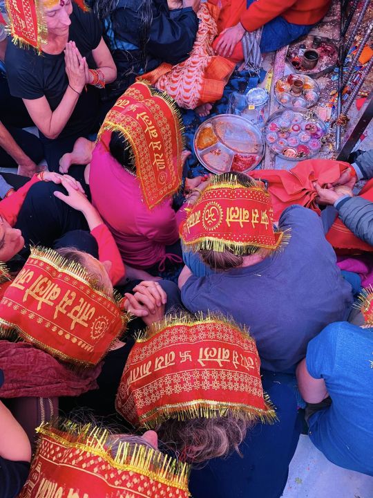
#indian himalayas
Photo
for how many lifetimes
have you been calling me to you, Devī?
for how many lifetimes
have i cowered?
for how many lifetimes
have i been lost, Devī?
for how many lifetimes
have you watched me stumble?
i have been through many wombs
to rest my head at your feet today.
yet here i am,
my Devī.
would it be
greedy of me
to plead with you
one more time?
will you
grace me?
will you
wash away
my good, my ugly?
my irreverences, my pride?
my agonies, my beauty?
will you
cleanse this heart
until i am nothing but flow
rushing forth to meet your shores
like the water running between your locks
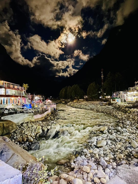
🤍 what came to me upon seeing the magnificence of Gaṅgā Devī for the very first time. photo: Gangotri at night.
#gangotri#ganga#ganges#ganga devi#poem#poetry#devotional poetry#bhakti poetry#bhakti#himalayas#indian himalayas#india#travel#uttarhand#uttarkashi#rishikesh#yatra#pilgrimage#sabda institute#sabda yatra#poetess#tea nicolae poetry
16 notes
·
View notes
Text
Kedarkantha Trek in Uttarakhand - Kahlur Adventures
Embark on an unforgettable journey through the stunning landscapes of the Indian Himalayas with Kahlur Adventures' Kedarkantha Trek in Uttarakhand. Experience the awe-inspiring beauty of the mountains while discovering hidden gems along the way. Discover more about this thrilling adventure at Kahlur Adventures.
#Kedarkantha Trek#Uttarakhand#Indian Himalayas#Adventure Travel#Mountain Exploration#Hiking#Outdoor Adventure#Nature#Trekking Experience#Kahlur Adventures
0 notes
Text
Tosh Glacier: Exploring the Majestic Frozen Wonderland of Indian Himalaya
Nestled in the breathtaking Kullu Valley of Himachal Pradesh, the Tosh Glacier stands as an awe-inspiring testament to the grandeur of the Indian Himalayas. This majestic frozen wonderland, with its captivating landscapes and serene ambience, beckons adventurers from around the world. In this comprehensive guide, we invite you to join us on a journey deep into the heart of Tosh Glacier, exploring…
View On WordPress
0 notes
Link
Discovering the Beauty and Adventure of Trekking in the Himalayan Mountains
Trekking in the Himalayan mountains is an unforgettable experience that offers breathtaking views, challenging trails, and a chance to explore some of the world's highest peaks. The Himalayas are home to many of the highest mountain ranges on Earth, including Mount Everest, the highest peak in the world at 8,848 meters (29,029 feet).
Read more at Trekking in the Himalayan Mountains
#Himalayan#Mountains#Indian himalayas#mount everest#the Himalayas#trekking in the Himalayas#Trekking in the Himalayan Mountains#Worlds tallest mountains#trekking in India#alkofholidays
0 notes
Text
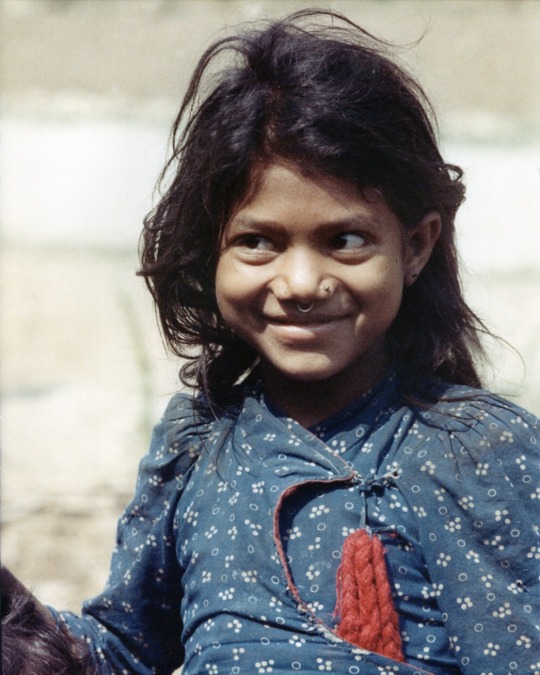


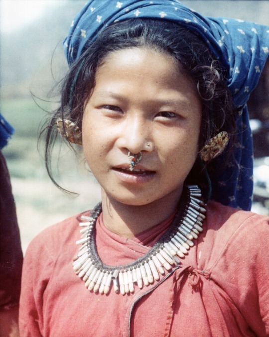


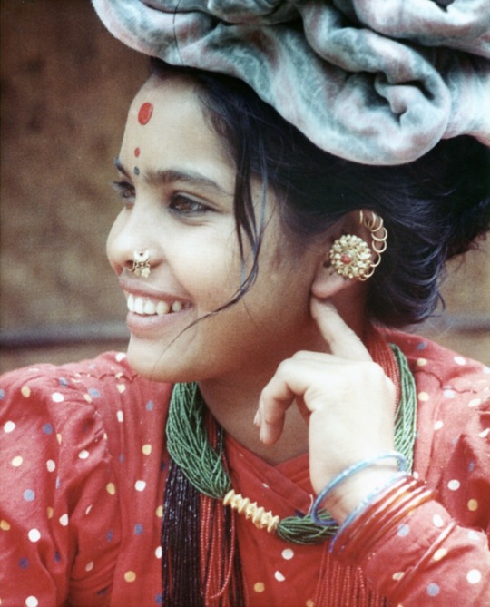
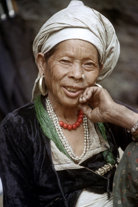

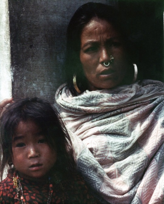


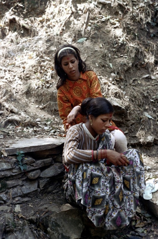
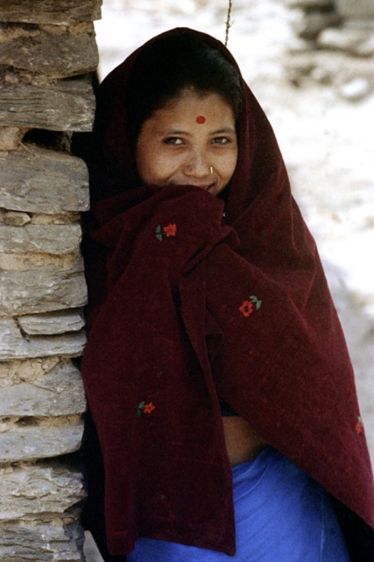
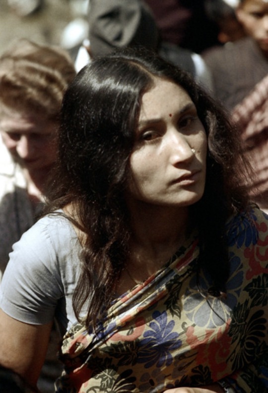

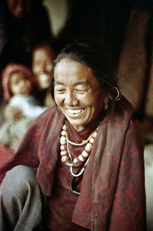

Women and girls of Nepal, 1972.
Photographed by Nick DeWolf.
#1970s#women#*#nepal#nick dewolf#60s 70s 80s 90s#1972#himalayas#south asia#photography#vintage#vintage photos#vintage photography#asia#old photography#women in photography#old photos#nepali#indian#women's empowerment#women's rights#70s#1970s vintage#70s vintage#travel#travel photography
70 notes
·
View notes
Text
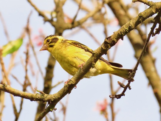
Yellow-breasted greenfinch (Himalayan greenfinch),
Pangot, October, 2023
#greenfinch#himalayan greenfinch#yellow#yellow-breasted greenfinch#small birds#birds#Himalayan birds#yellow birds#Pangot#himalayas#mountains#perches#trees#wildlife#Indian aves
21 notes
·
View notes
Text
Nyalmo

“Ulvenwald Bear” © Wizards of the Coast, by Jason Engle. Accessed at the artist’s deviantArt here
[Commissioned by @abominationimperatrix. The nyalmo is a type of yeti, which goes to show how far the cryptozoological yeti has moved from its folkloric roots. A twenty foot sapient bear is not an eight foot ape-man, no matter how hard you try. The information here comes from Ghosts, Monsters and Demons of India. Mechanically, this is built around the chassis of a dire bear with the giant template for the ability scores, and I tied them to the similar sapient bipedal bears the urskans through their language.]
Nyalmo
CR 10 N Magical Beast
This creature resembles an enormous bear, except that it seems more comfortable walking on its hind legs. Its arms are long and end in great claws.
The nyalmo are enormous sapient bears that live in the high mountains. They often descend to lower elevations in search of food; although a nyalmo can persist on moss, lichens and insects, they much prefer fresh meat, particularly brains and other fatty tissue. They have little concept of private property, so do not understand that the livestock owned by ranchers belongs to someone else; to a nyalmo, it is merely a convenient depot of food. This raiding may bring nyalmo into conflict with humanoids, a fight that the nyalmo’s great size and strength typically makes an uneven contest. Nyalmo rarely have complicated strategies—tear prey apart with claws and teeth, grab them and break their bones. They flee from enemies that are able to keep their distance, and rarely attack a fortified position.
Nyalmo live in small matriarchal groups, led by the oldest female. Nyalmo have little material culture, but do have culture nonetheless. They are in tune with their surroundings, and read portents in the position of the stars, the movement of birds, and the spilling of entrails. The latter of these portents have supernatural significance, and many nyalmo have had their life saved by some augury they saw in this ritual. During celestial configurations such as the first appearance of a constellation or a solstice, nyalmo gather under the open sky to drum and sing. A few nyalmo have even been known to abduct a humanoid and keep them as something between a pet and a tutor, trying to learn from them the secrets of human language, fire, or ironworking. They care quite a bit for these captives, but will eat their captives if they cross the nyalmo one too many times.
A nyalmo stands between fifteen and twenty feet tall—nyalmo women are taller than the men. They have a garlicky odor, and their dens are typically quite pungent.
Nyalmo CR 10
XP 9,600
N Huge magical beast
Init +4; Senses darkvision 60 ft., low-light vision, Perception +10, scent
Defense
AC 24, touch 8, flat-footed 24 (-2 size, +16 natural)
hp 126 (10d10+70)
Fort +14, Ref +7, Will +8
Resist cold 10
Defensive Abilities haruspicy
Offense
Speed 40 ft.
Melee 2 claws +17 (2d6+9/19-20 plus grab), bite +17 (1d8+9)
Space 15 ft.; Reach 15 ft.
Special Attacks neck breaker
Statistics
Str 29, Dex 11, Con 25, Int 6, Wis 16, Cha 10
Base Atk +10; CMB +21 (+25 grab); CMD 31
Feats Blind-fight, Improved Critical (claw), Improved Initiative, Iron Will, Skill Focus (Survival)
Skills Climb +14, Perception +10, Survival +17; Racial Modifiers +4 Survival
Languages Urskan
SQ pungency, snow walker
Ecology
Environment cold hills and mountains
Organization solitary, pair or clan (3-8)
Treasure incidental
Special Abilities
Haruspicy (Su) A nyalmo can gain insights into the future by spending one minute consulting the entrails of a freshly killed animal. For the next 24 hours after it performs this ritual, it may treat a saving throw as if it rolled a 20. It may use this ability a number of times per day equal to its Wisdom modifier.
Neck Breaker (Su) If a nyalmo succeeds at maintaining a pin, the pinned creature must succeed a DC 24 Fortitude save or take 2d6 points of Dexterity damage. Any damage dealt beyond reducing the creature’s Dexterity to 0 is applied to its Constitution instead. The save DC is Strength based.
Pungency (Ex) A nyalmo can be detected at twice the normal distance by scent.
Snow Walker (Ex) A nyalmo ignores all difficult terrain created by natural snow or icy conditions.
70 notes
·
View notes
Text

Exploring Dooars | Episode - 1 | North Bengal Dooars Vlog | Offbeat Chisang (The Wildwoods Retreat) - https://youtu.be/xZbZMWLJO_c
2 notes
·
View notes
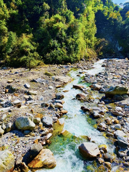
Photo

The always beautiful view of villages and temple as the sun retreats behind the mountains
4 notes
·
View notes
Photo


the last days of the Śabdācāra Yātra: Yamunotri & the mystical Yamunā Devī.
#yamuna#yamuna devi#yamunotri#sacred#river#holy#goddess#yatra#sabda institute#pilgrimage#sabda yatra#sabdacara#himalayas#indian himalayas#india#travel#yogini#tantra#kavitha chinnaiyan#non-dual tantra#beauty#nature
5 notes
·
View notes
Text
"To the east of Trisul, and set farther back, you can just see the top of Nanda Devi (25,689 feet), one of the highest mountains in India. To your right front is Nanda Kot, the spotless pillow of the goddess Parvati, and a little farther east are the beautiful peaks of Panchchuli, the ‘five cooking-places’ used by the Pandavas while on their way to Kailash in Tibet. At the first approach of dawn, while Cheena and the intervening hills are still shrouded in the mantle of night, the snowy range changes from indigo blue to rose pink, and as the sun touches the peaks nearest to heaven, the pink gradually changes to dazzling white. During the day the mountains show up cold and white, each crest trailing a feather of powdered snow, and in the setting sun the scene may be painted pink, gold, or red according to the fancy of heaven’s artist."
- Jim Corbett ( My India)
#books#english literature#quotes#words#dark academia#literature#dark acadamia aesthetic#dark academia quotes#poetry#classic books#beauty#himalayas#jim corbett#indian writer#india#indian aesthetic#lord shiva#goddess parvati#mountains#mount kailash#authors#writers#books & libraries#bookworm#booklover#bookstagram#book aesthetic
4 notes
·
View notes
Text
0 notes
Text
The moment having India Flag in hands at such places makes me proud on myself always.
.........
#india #IndianFlag #ILiveMyIndia #Kedarkanta #Trekking #KedarkanthaVlog #TravelIndia #IndianVlogger #RidingYogi #LucknowTravelVlogger #KedarkanthaPeak #TreakIndia #Uttarakhand
#indian biker#I love my india#indian flag#kedarkantha summit#uttarakhand#explore india#indian travel vlogger#lucknow travel vlogger#adventure trip#winter trek india#best indian trek#Lucknow biker riding yogi#indian biker riding yogi#himalaya trek
2 notes
·
View notes
Text
Hey All,
I've been away for some time, as we've been working really hard on something quite exciting:
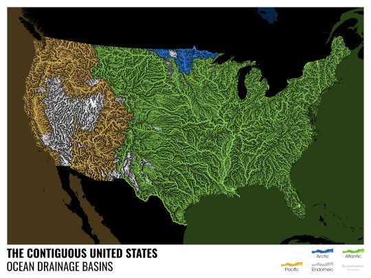
let me present to you the world's first ever global ocean drainage basin map that shows all permanent and temporary water flows on the planet.

This is quite big news, as far as I know this has never been done before. There are hundreds of hours of work in it (with the data + manual work as well) and it's quite a relief that they are all finished now.
But what is an ocean drainage basin map, I hear most of you asking? A couple of years ago I tried to find a map that shows which ocean does each of the world's rivers end up in. I was a bit surprised to see there is no map like that, so I just decided I'll make it myself - as usual :) Well, after realizing all the technical difficulties, I wasn't so surprised any more that it didn't exist. So yeah, it was quite a challenge but I am very happy with the result.
In addition to the global map I've created a set of 43 maps for different countries, states and continents, four versions for each: maps with white and black background, and a version for both with coloured oceans (aka polygons). Here's the global map with polygons:
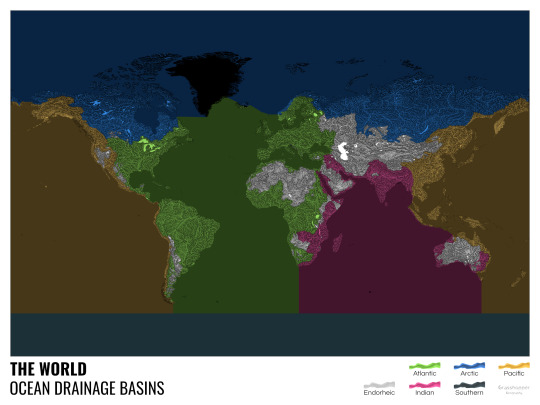
I know from experience that maps can be great conversation starters, and I aim to make maps that are visually striking and can effectively deliver a message. With these ocean drainage basin maps the most important part was to make them easily understandable, so after you have seen one, the others all become effortless to interpret as well. Let me know how I did, I really appreciate any and all kinds of feedback.
Here are a few more from the set, I hope you too learn something new from them. I certainly did, and I am a geographer.
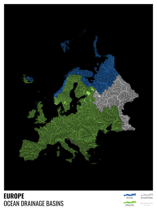
The greatest surprise with Europe is that its biggest river is all grey, as the Volga flows into the Caspian sea, therefore its basin counts as endorheic.
An endorheic basin is one which never reaches the ocean, mostly because it dries out in desert areas or ends up in lakes with no outflow. The biggest endorheic basin is the Caspian’s, but the area of the Great Basin in the US is also a good example of endorheic basins.
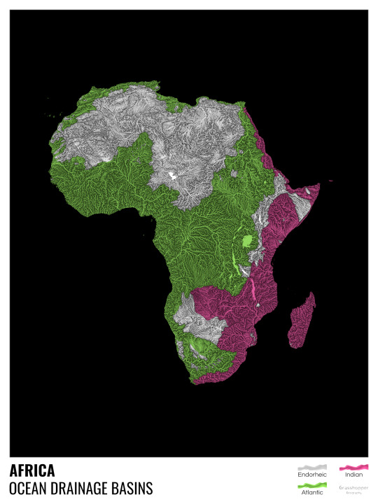
I love how the green of the Atlantic Ocean tangles together in the middle.
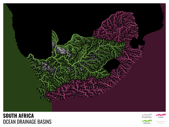
No, the dividing line is not at Cape Town, unfortunately.
I know these two colours weren’t the best choice for colourblind people and I sincerely apologize for that. I’ve been planning to make colourblind-friendly versions of my maps for ages now – still not sure when I get there, but I want you to know that it’s just moved up on my todo-list. A lot further up.
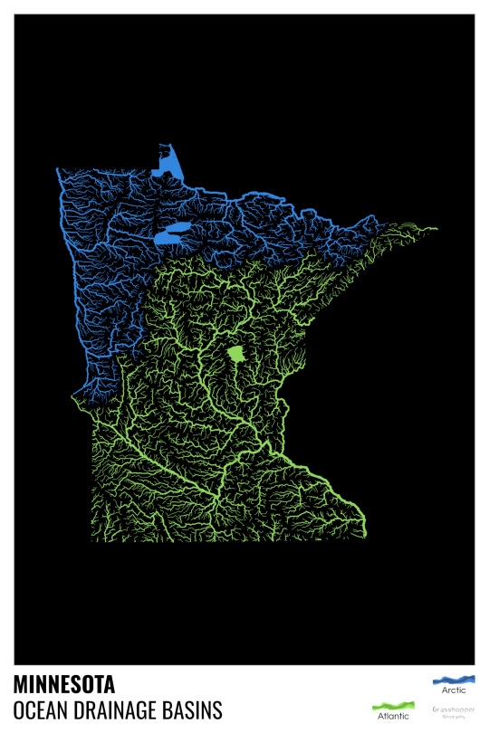
Minnesota is quite crazy with all that blue, right? Some other US states that are equally mind-blowing: North Dakota, New Mexico, Colorado, Wyoming. You can check them all out here.
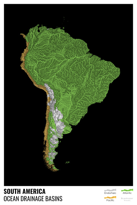
Yes, most of the Peruvian waters drain into the Atlantic Ocean. Here are the maps of Peru, if you want to take a closer look.
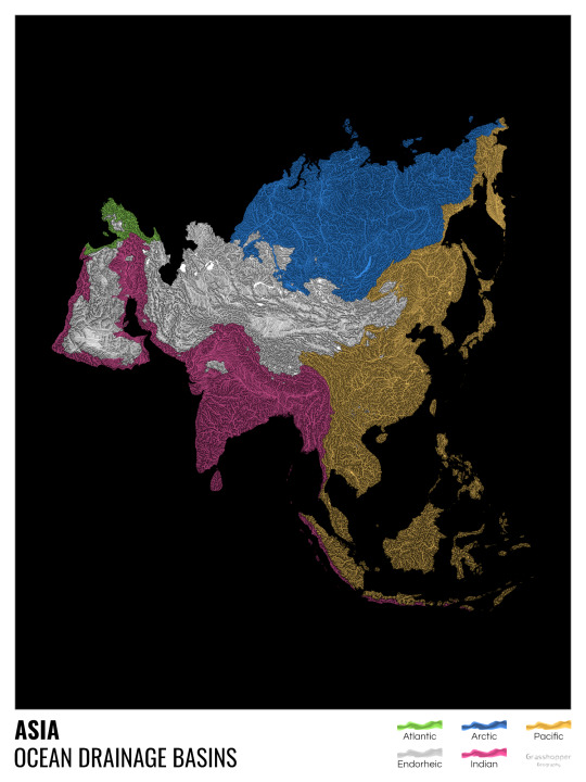
Asia is amazingly colourful with lots of endorheic basins in the middle areas: deserts, the Himalayas and the Caspian sea are to blame. Also note how the Indonesian islands of Java and Sumatra are divided.
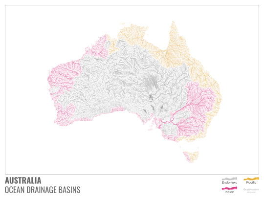
I mentioned earlier that I also made white versions of all maps. Here’s Australia with its vast deserts. If you're wondering about the weird lines in the middle: that’s the Simpson desert with its famous parallel sand dunes.
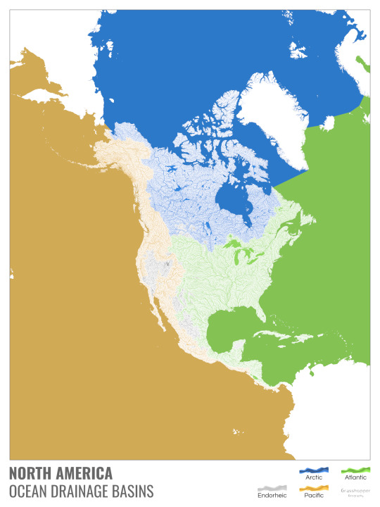
North America with white background and colourful oceans looks pretty neat, I think.

Finally, I made the drainage basin maps of the individual oceans: The Atlantic, the Arctic, the Indian and the Pacific. The Arctic is my favourite one.
I really hope you like my new maps, and that they will become as popular as my river basin maps. Those have already helped dozens of environmental NGOs to illustrate their important messages all around the world. It would be nice if these maps too could find their purpose.
#maps reimagined#geography#cartography#maps#my art#rivers of the world#ocean drainage basins#ocean maps#river maps
16K notes
·
View notes
Text
Spotted forktail,
Pangot, October, 2023
#pangot#uttarakhand#spotted forktail#forktail#himalayas#birds#black and white#monochrome#black and white birds#streams#water#rushing water#nature#big birds#wildlife#indian aves#Vimeo
19 notes
·
View notes
Last Seen Blogs

sublimepandadream
Untitled


bleed-more
Yes I'm Still Into Marble Hornets

ally-enigena
† All †

pluto247
pluto247