#Oneota pottery
Photo
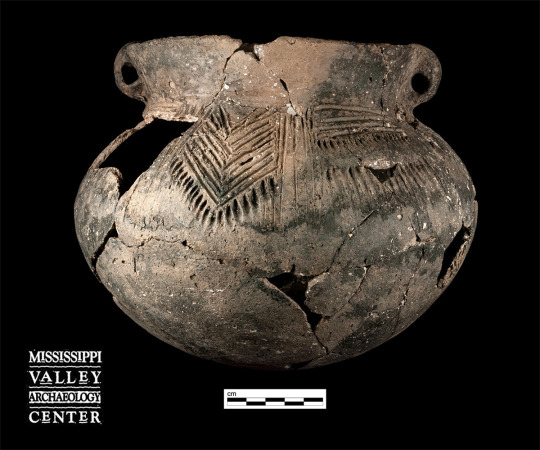
This reconstructed pot, designated Vessel 46, was found in Feature 199 during the 2012 excavations under STH 35 in downtown Onalaska, Wisconsin. The nearly complete vessel is a classic example of Brice Prairie phase Perrot Punctate. The rim is moderately high for the vessel size and is slightly outward-flaring, with small, interior tool impressions. Two small loop handles attach at the lip top on opposite sides. The shoulder has alternating panels of vertical tool trails; nested chevrons (about eight) with a border of long, slash punctations below; vertical tool trails; and four horizontal tool trails with a lower border of long slash punctations, and short vertical tool trails below those. There are four nested chevron panels, one under each handle and the others midway between them. The rim radius is 7 cm, flaring slightly to 7.5 cm at the handles.
#archaeology#archeology#Pottery#Ceramics#Oneota#Oneota pottery#Oneota ceramics#Perrot Punctate#Brice Prairie phase
52 notes
·
View notes
Photo
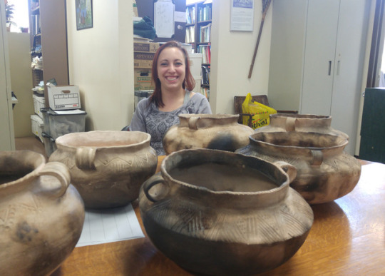
#tbt to a month ago when we visited @uwlmvac, where Sarah Schultz has been experimenting with re-creating Oneota-style pottery vessels! Sarah donated one to us for our teaching collection and one to the Baxoje Wosgąci: Iowa Tribal Museum and Culture Center. It was great to visit our WI colleagues!
#iowa#wisconsin#archaeology#oneota#experimental archaeology#pottery#ceramics#art#tbt#throwback thursday
14 notes
·
View notes
Text
EARS TO THE GROUND
BY TIMOTHY A. SCHULER / PHOTOGRAPHY BY LOUISE JOHNS
Three hundred years ago, Blood Run was a hub of the Great Plains. The landscape architect Brenda Williams is helping guide tribal efforts to protect what’s left, mostly by listening.
FROM THE AUGUST 2017 ISSUE OF LANDSCAPE ARCHITECTURE MAGAZINE.
On a cold, blustery morning last November, I followed an abandoned railroad grade to the South Dakota and Iowa state line. I had two maps in front of me—one an annotated paper printout, a collage of colors and lines overlaid on an old topo map, and the other Google Maps, open on my phone, my blue dot tacking southwest. I wasn’t lost. I was on a trail that did not yet exist.
The route, unmarked and at points choked by trees, had been outlined to me a few days earlier by Brenda Williams, ASLA, a landscape architect and director of preservation planning at Quinn Evans Architects in Madison, Wisconsin. Williams had recently led the development of a master plan for this area, an important but not widely known archaeological site known as Blood Run. The old railway was the proposed arrival sequence.
Typically, the few visitors who came to Blood Run, which became a National Historic Landmark in 1970, parked at the top of a bluff and followed a path down to the Big Sioux River, the state border. But Williams had been explicit: Take the railroad grade. Rather than start high, Williams wanted visitors to begin in the valley, to park and walk along the creek that gives the area its name before reaching the earthen mounds that are some of the site’s more visible cultural and historic remnants. It was, in part, a practical decision: The abandoned railroad provided a level path all the way from the main road to the mound grouping. But mostly it was about being immersed in the place, bringing people into the site with as few visual intrusions as possible, as few opportunities to break the spell.
To American tourists used to the grandeur of Yellowstone or Yosemite, the landscape at Blood Run may seem unremarkable: gentle bluffs covered in prairie grass, occasional stands of box elders and oaks, and, near the river, an old, stone farmstead, sunken in like a piece of rotted fruit. But as one member of the Iowa Tribe of Kansas and Nebraska put it, “Even commonplace landscapes can have mythic importance. Blood Run is such a place.”
Blood Run has gone by many names over the years. A Sioux Falls physician, Frederick W. Pettigrew, called it the Silent City. The Omaha people called it Xe (pronounced breathily like khay), or the place “where something is buried.” It is unclear when or why it became known as Blood Run. Some think the name comes from the area’s ubiquitous pink Sioux quartzite, which could have turned the creek’s water red; another theory is that Blood was a surname. What is generally agreed upon is that Blood Run was not, as the name might suggest, a massacre site. Rather, it was a place of peace.
Several structures remain on site, visible from the existing path. Photograph by Louise Johns.
Blood Run is the largest and best-preserved historic site associated with what archaeologists call the Oneota cultural tradition, which is characterized by a style of shell-flecked pottery, though the term generally is not used by members of the many tribal nations—including the Ioway, Omaha, Ponca, Otoe, Missouria, Winnebago, Osage, and Kansa—that maintain ancestral connections to the area. According to tribal histories and archaeological evidence, the area once supported as many as 10,000 people. It was inhabited continuously from AD 1500 to 1714, a cultural and economic hub contemporaneous with the formation of the American colonies. Blood Run had barely even been established when Christopher Columbus mistook the Bahamas for the East Indies.
People from across the continent made stops here, trading pottery and later European goods for catlinite, a soft, red stone quarried some 50 miles to the north at what is now Pipestone National Monument in Minnesota. Tribes also traded ceremonies and songs. Randy Teboe, who until recently served as the director of cultural affairs for the Ponca Tribe of Nebraska, describes the city as a refuge, far from the conflicts erupting on the East Coast. Here, tribes built alliances that were called upon as they were driven from their homelands.
Today, there is little hint of that refuge. By the middle of the 20th century, 200 years of European settlement had nearly erased this one-time city. Of what had been hundreds of mounds, built for burial and ceremonial purposes, just 68 remained.
Image courtesy of Quinn Evans Architects.
In 1988, the governors of Iowa and South Dakota announced their intention to turn Blood Run into a bistate park. It would be a first for the United States, and a signature project of their administrations. Soon after, a bistate committee was formed to begin the planning process. In the decades since, both states have made significant progress toward that vision, though at significantly different paces. South Dakota, after acquiring 650 acres, designated its half of the site as Good Earth State Park in 2013 and in May dedicated a new visitor center. Across the river, Iowa owns just 183 acres. There are no facilities or campgrounds, just a mowed-grass path and a small metal sign.
That the two states find themselves at such different stages is a result of politics and funding, but also a difference in approach. For years, South Dakota’s efforts were embroiled in conflict between the state and its tribal consultants (formal representatives from those tribes with ancestral ties to the site), due in part to the pace of construction. The landscape bears the imprint of this rift. In South Dakota, new gravel paths trace the contour of the river bluff but are cut off from Blood Run’s most significant resources. Visitors in Iowa, meanwhile, have no access to the areas of highest elevation, places that, for tribal members, hold particular spiritual significance. Today, rather than a truly borderless, jointly managed bistate park, Blood Run is two distinct halves of a historical whole.
Brenda Williams works out of a small upstairs office in her house in Madison. She is midwestern to a tee, polite and self-effacing. She makes her own mustard. She has a husband, a son, and two cats, Sky and Moku (a reference to mokume gane, a Japanese method of metalworking), which wander in and out of her office. She is known for having, in the words of one tribal representative, the “patience of Job.”
In 2015, the Iowa Department of Natural Resources (IDNR) hired Williams to develop a cultural landscape master plan for its portion of the Blood Run site. By then, a series of conflicts and disagreements had left many of the tribal consultants distrustful of South Dakota’s state officials. Lance Foster, the tribal historic preservation officer, or THPO, for the Iowa Tribe of Kansas and Nebraska, was one of them. Foster lives in White Cloud, Kansas, and works out of his tribe’s government offices, a collection of red-brick buildings plopped onto the rural landscape. He’s a bear of a man, but more teddy than grizzly. In overalls and a short-sleeved, button-up shirt, he looks as if he’s been farming this corner of Kansas for his entire life. In fact, Foster is trained as an anthropologist, an artist, and a landscape architect. Before he moved to White Cloud, he taught painting, drawing, and archaeology at the University of Montana and published The Indians of Iowa, an overview of the dozens of tribes that once called the state home. It was Foster who wrote, in American Indian Places: A Historical Guidebook, that commonplace landscapes like Blood Run can have “mythic importance.”
Marisa Cummings (left), an Omaha tribe member, near the remains of an old springhouse. Photograph by Louise Johns.
Foster consulted on both South Dakota’s and Iowa’s master plans. He says South Dakota’s officials presented the tribes with a mostly formed master plan and only then solicited comment. They also pursued a project schedule that did not allow for the customary consultation between a tribal consultant and his or her tribal council. “South Dakota had directions from their governor to rush ahead and get things done, which wasn’t always on a native timescale,” Foster says wryly. At one point, after a prominent South Dakota businessman questioned the importance of tribal involvement, Foster withdrew from the planning process.
Marisa Miakonda Cummings, an Omaha tribe member who has served as an official and unofficial consultant to both states, says the process was so “ugly” and disrespectful of her tribe that she threatened to organize a protest and shut down the entire project. “In our language, we have a word; it means, ‘They have no ears.’ They don’t listen,” Cummings says. “And that’s what was happening.”
In 2015, when those same tribe members were asked to attend a meeting for Iowa’s master plan, Cummings says she expected more of the same. “We were called to a meeting, and Brenda and her husband are there. And bless Brenda’s heart, we were just at her throat. Like, ‘What are you trying to give us? Show us whatever you’re trying to do,’” Cummings recalls. (Williams’s husband, Dan Williams, ASLA, is a landscape architect at Lunde Williams and a member of the project team.) “And she kept saying, ‘Well, that’s why we’re here. We’re waiting to hear what you have to say.’ And it took her probably half a day of saying that over and over again before we were like, ‘Oh, you really want to start from ground zero.’”
That posture, Cummings says, “created this entirely different dialogue about what would we really want? We want to educate people. We want to show them all of our biodiversity. We want to show that we weren’t roaming around just chasing a buffalo with a spear, but that we were agriculturalists. We were engineers. We were architects.”
Randy Teboe (second from left) walks the future state park with Brenda Williams, ASLA, (foreground) and tribal representatives. Photograph by Louise Johns.
It would be an exaggeration to suggest that Williams alone was responsible for the smoothness of Iowa’s master plan process. Dozens of factors were in play, including the two states’ disparate timelines, which gave the Iowa team an opportunity to learn from South Dakota’s missteps. Iowa also has a history of successful tribal engagement. In the 1970s, battles between archaeologists and indigenous rights activists led to the passage of the Iowa Burials Protection Act of 1976, the first U.S. law to specifically protect indigenous peoples’ remains. That law was a precursor to the Native American Graves Protection and Repatriation Act, or NAGPRA. “They have really led the way,” Foster says of the state.
At Blood Run, IDNR wanted the engagement process to guide the master plan and was even willing to relinquish the idea of a bistate park. “[They] said, ‘We want you to tell us what it should be,” Williams says. In its RFP, the state asked design teams to visit the tribes at their homes, but Williams thought it equally important that the tribal representatives be on site as much as possible. She included money in her budget for representatives from the most closely associated tribes to travel to Blood Run.
Over the next year, the Iowa team—which included Iowa’s state archaeologist, as well as the archaeologist Dale Henning, who served as an adviser to the tribes—formed a close bond, joking and teasing one another. “It’s all about spending time with someone, one to one,” Foster says. “It’s not like a usual client situation. Spend a lot of time with us, get to know us as a person, as a friend, and we will find a way to make it work together.” With Williams, “we all became a team,” he says. “That’s how we saw ourselves.”
Iowa’s master plan, which covers some 3,880 acres, including property beyond the current National Historic Landmark boundary, calls for interpretative facilities, campgrounds, and a large bioreserve, complete with a herd of bison. The main trail—which currently cuts through the main mound grouping and leads to one of Blood Run’s unique pitted boulders, large chunks of Sioux quartzite covered in small, man-made divots—will be moved to protect these resources. New, low-impact secondary trails will be added, along with low platforms that will provide people enough height to see the mounds but will not damage them. Where trails cut through historic resources, they will feature a different material as a visual reminder to visitors that they are within a sensitive area. Some places of spiritual or cultural significance will be completely off-limits. Rather than draw attention to them through interpretation, the state will protect these areas by giving them wide berth.
Based on feedback from tribal representatives, the Iowa team also realized that it needed a long-range interpretation and education plan alongside the master plan. Iowa’s approach calls for interpretative facilities at every entrance to the park, to inform visitors how to conduct themselves on site and to provide occasions for reflection at the conclusion of a visit. It was important to many of the tribal representatives that the experience be fluid, changing with the seasons, much like the lives of those who lived at Blood Run.
Blood Run carves a course through a landscape of low terraces. Photograph by Louise Johns.
And then, of course, there is the need to stitch the site back together. “Obviously, if this is going to be a holistic place, there [need to be] ways to get across the river,” Williams says. “[We] can’t keep talking about South Dakota versus Iowa.” The design team analyzed potential bridge locations, including the old railroad abutment, which had a consistent grade on both sides and a possible connection to a regional bike trail. But some of the tribal representatives were horrified at the idea, Williams says, because the railroad cut through one of the area’s most dense concentrations of historic resources. “That was so huge for us to hear that,” Williams tells me. Eventually, a footbridge was suggested north of Iowa’s current entrance. “You need to have that connection, but it needs to be pedestrian,” she says. “No cars, no bikes.”
Despite the admittedly light hand Quinn Evans has employed, Williams says she has some trepidation. In a place that is so treasured, any intervention can feel intrusive. “There’s nothing there yet,” she says. “And yet all we can do is ruin it. That’s the fear of creating this thing.”
Williams has devoted her career to cultural landscapes like Blood Run, working with public clients such as IDNR and the National Park Service (NPS). “And that is where I belong,” she tells me. “I have this really insatiable desire to try to make things right with these places that are so special and that I feel like keep getting lost.” But exactly what it means to “make things right” has shifted for Williams over the years. Through projects like Blood Run, she’s gained a newfound appreciation for indigenous knowledge—and also seen it dismissed by government officials and even other designers. She’s been forced to confront her own ignorance and challenge business-as-usual approaches to “stakeholder engagement.” And she’s had to accept that, as a design professional, her rights extend only so far when it comes to a tribe’s particular beliefs and practices. “One of the points that I talk about is not asking for information,” she says. “Not ‘What is important?’ but ‘How do we protect what is important?’”
Recently, Williams has begun writing and speaking about her work, and she’s developed a checklist for landscape architects. Number one: Investigate whether or not a tribe was ever associated with a site. The answer may appear obvious, she says, but many tribes were forced from their homes, relocated to unclaimed territory. Tribes whose reservations today are in Kansas or Nebraska often maintain deep ties to lands hundreds of miles away. At Blood Run, associated tribes live as far away as Perkins, Oklahoma, 600 miles to the south.
Number two: Include tribal engagement in the project scope, even if just as an optional service. (When Williams has done so, the client has always added it in, she says.) Number three: Deal only with a formal representative who is authorized to speak on behalf of the tribe. This third point has been made simpler by the creation of the THPO (often pronounced “tippo”) role. Following centuries of disenfranchisement, in 1992, an amendment to the National Historic Preservation Act created the THPO program. Besides giving government agencies an official point of contact, a tribe’s THPO gained the authority to make preservation decisions on tribal lands, previously the jurisdiction of the state historic preservation officer. In 1996, with $958,500 from the National Historic Preservation Fund, 12 tribes hired their first THPOs. Today there are 171.
Federal funding has gone toward not just hiring but training the THPOs. This has opened up new professional opportunities for tribe members and provided a firmer foundation regarding the legal ins and outs of legislation like NAGPRA. Though the program has its shortcomings (a shrinking pot of money among them), THPOs have become crucial liaisons to both sides, translating their tribes’ protocols for the project team and the planning jargon for the tribal council.
“The good thing about having a THPO is that you usually encounter somebody who at least has some training, some awareness not only of culture and the law, but is also usually educated and willing to engage with the outside world,” Foster says.
Williams also advises her clients to build long-term relationships with tribal representatives, because questions that weren’t considered inevitably arise, and tribes should be involved. “There will be decisions about, ‘Can people come here and have a dog show? Is that offensive or not?’” she says.
Williams explained her philosophy as we trekked to the top of Effigy Mounds National Monument south of Harpers Ferry, Iowa, some 300 miles east of Blood Run. Williams completed a cultural landscape report for Effigy Mounds, which encompasses 2,500 acres along the Mississippi River, around the same time as she developed the master plan for Blood Run and worked with many of the same THPOs.
Effigy Mounds provides a glimpse into Blood Run’s future. The mounds that give the place its name—massive earthen structures, some more than 200 feet long, formed into the shapes of bears and birds—are easy to make out, thanks to a landscape treatment that provides contrast. Herbaceous plants are being encouraged atop the mounds, which will be burned on rotation, and grass around the mounds is mowed short to exaggerate the relief. Williams is recommending similar practices at Blood Run.
Effigy Mounds is also a testing ground for how to turn the management of cultural resources over to associated tribes, for whom the how is often as important as the what. At Effigy Mounds, for instance, certain trees need to be removed for the sake of the mounds, which can be damaged by falling limbs. But how those trees are cut down and hauled away is consequential, Williams says, because the trees are sacred too. Currently, protocols have been established to ensure sensitivity, but the hope is that these decisions will eventually be placed in the hands of the tribes—something Williams says could happen soon. The master plan for Blood Run recommends that IDNR do something similar where appropriate.
Working in these places has deepened Williams’s appreciation for just how personal they are. Albert LeBeau, the cultural resources manager at Effigy Mounds, is an archaeologist and member of the Cheyenne River Sioux Tribe. He’s been part of an effort to improve relations between tribes and entities such as NPS and worked with Williams on the cultural landscape report. Growing up, he tells Williams and me, he attended a reservation school outside Missoula, Montana, where he felt “brainwashed” by history books that referred to indigenous people as “savages.” He became an archaeologist to protect his ancestors, whose bones continue to be desecrated. “When you go out on an island in the Missouri River, and you stop counting skulls at one hundred—when you see the skeleton of a baby, whose femurs have been removed and placed next to them in a skull-and-crossbones fashion—that’s why I do it,” he says.
A similar mission motivates Randy Teboe, who consulted at Blood Run on behalf of the Ponca and is now the cultural preservation director and THPO for the Winnebago Tribe of Nebraska. Teboe grew up in Nebraska in the foster care system, starved for a connection to his culture, he says. Eventually, he got a job with his tribe and soon after became the THPO. He first visited Blood Run several years ago, and immediately felt a personal connection. “I was out there by myself, and I could hear drums and singing. I went to a different part of the park, and I could smell food cooking. I know that’s some kind of Jedi stuff. But that’s the feeling that I got.” The way he understands it now is that his ancestors wanted him to grasp Blood Run’s importance. “They were speaking to me,” he says. “They were trying to show me the way.”
Williams put it this way: “This is way beyond the physical landscape. This is about sense of place as a part of the science of how we design places. It is not magic. It’s not weird spiritual hoo-ha.” It’s the only chance these places have of surviving, she says. If landscape architecture is to reckon with climate change or any of the myriad issues facing the planet, that effort “has to be informed by an equal understanding of the importance of culture,” she says. “American Indians, and the way they look at the world, can help us understand that.”
In January 2016, Williams was hired by South Dakota to assist the state in its engagement efforts as it developed the exhibits for its visitor center. It was confirmation that Iowa’s approach had worked, and that others had taken notice. Doug Hofer, who recently retired as the director of South Dakota Game, Fish, and Parks, says Blood Run forced the state to reevaluate its approach to tribal consultation. “The state has a greater appreciation for both the skill and the passion that the tribes have to interpret their history and their culture accurately,” he says. “I think we’ve learned that the input that we get really is helpful to the final product. I’d go so far as to say it’s essential.”
The arrival of Jim Henning, the park manager of Good Earth State Park, also bodes well. Boyish and naturally curious, Henning was hired in summer 2016, inheriting a more positive template for how to work with tribal representatives. He sees in Williams someone to emulate. “She’s inspiring,” he says. “Her being a part of the conversation helped everybody. I think it helped Iowa, and I think it helped South Dakota.” Henning’s supervisors have encouraged him to visit the tribes on their homelands, and he recently spent a half day with the Ponca in Nebraska. “They have [a] connection to this place that I want to try to understand as best I can in order to respect that story,” Henning says. “If I’m not doing that, I shouldn’t be here, honestly.”
As for Iowa, the state is working to acquire the parcels of highest priority, but it will likely take years before the construction can begin. In the interim, much of the site remains unprotected, in the hands of private landowners. Still, many of those I spoke with expressed hope that each of the entities involved—the states, the tribes, the landowners—would continue to find common ground.
This is, after all, the meaning of “good earth.” The phrase comes from the Iowa word “MayanPi,” which means “to make peace,” Foster tells me. “To cause something to become good earth, that’s how we say to make peace.” Though finding a name has been controversial in itself, the goal, Foster says, was to find one that anyone, indigenous or otherwise, could say in their language. It was a gesture toward the land’s shared ownership, giving each tribe and state a way to claim a place that has been home for many. It also can be seen as a wish for the future, when Blood Run might once again be a place of peace.
Timothy A. Schuler writes about landscape architecture, ecology, and urban design. He lives in Honolulu.
Project Credits
Client State of Iowa Department of Natural Resources, Des Moines, Iowa (Todd Coffelt). Landscape Architects Quinn Evans Architects, Madison, Wisconsin (Brenda Williams, ASLA, and Stephanie Austin, Associate ASLA); Lunde Williams, LLC, Madison, Wisconsin (Dan Williams, ASLA). Interpretative Planning Quinn Evans Architects, Washington, D.C. (Alyson Steele and Julia Siple). Consultants Iowa Office of the State Archaeologist, Iowa City, Iowa (John Doershuk, Lara Noldner, John Hedden, Mary De La Garza); State Historical Society of Iowa, Des Moines, Iowa (Jen Bancescu); Coolfire Conservation, Madison, Wisconsin (Paul West); Omaha Tribe of Nebraska, Macy, Nebraska (Marisa Miakonda Cummings and Thomas Parker); Iowa Tribe of Kansas and Nebraska, White Cloud, Kansas (Lance Foster); Ponca Tribe of Nebraska, Niobrara, Nebraska (Randy Teboe and Shannon Wright); Iowa Tribe of Oklahoma, Perkins, Oklahoma (Eagle McClellan); and the Otoe-Missouria Tribe, Red Rock, Oklahoma (Galen Springer).
from Landscape Architecture Magazine https://landscapearchitecturemagazine.org/2017/09/26/ears-to-the-ground/
0 notes
Text
Shell-Tempered Pottery From the Upper Mississippi River Valley
Author: Robert F. Boszhardt
Abstract: Shell-tempered ceramics first appear in the archaeological record of the upper Mississippi River Valley in the post-Hopeivellian period (ca. A.D. 250-500) of the Woodland Tradition as a minority ware in northwestern Illinois and south-central Wisconsin. Following a five-century hiatus, shell tempering was reintroduced via Middle Mississippian expansion from the American Bottom into the northern hinterland about A.D. 1000-1050. The following century witnessed the adoption of this technology by Terminal Woodland groups as they also incorporated corn agriculture into their economy. After A.D. 1150, shell tempering dominated the ceramics of the intensive agricultural Oneota Culture until French contact and the coinciding introduction of brass kettles. Experimental replication of Oneota wares, coupled with archaeological evidence, offers insight into the manufacturing technology of this last prehistoric culture in this region.
0 notes
Photo

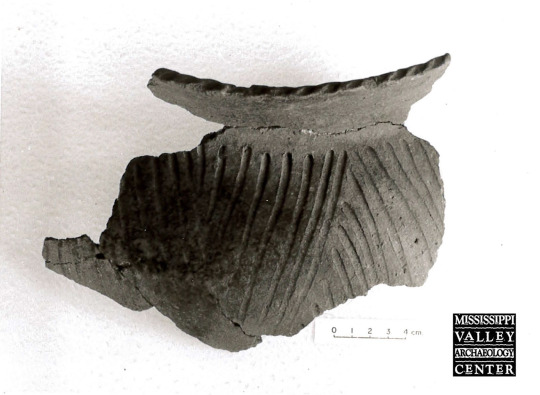
This vessel fragment from 2012 excavations in Onalaska, Wisconsin, has a short, strongly outward-flaring rim with fingertip impressions on the lip top. That's not all that makes this pottery sherd interesting, though. The design on the shoulder features (from top to bottom) two horizontal rows of ovoid punctations, a horizontal finger trail, another horizontal row of punctations, another horizontal finger trail, and another horizontal row of punctations. This design is quite unusual for the La Crosse area; however, the vessel’s paste (the clay from which it was made) and the crushed-shell temper added to improve firing both look typical for local pottery. Perhaps the potter who made the vessel was non-local, or had encountered the design elsewhere?
16 notes
·
View notes
Text

This intriguing feature was uncovered in 2009 during excavations in a former cultivated field in the Sand Lake Archaeological District near Onalaska. The soil within the feature was dark, like a storage or refuse pit, but the size and shape suggested it was something different--a semisubterranean, keyhole-shaped house. The feature measured about 5.4 by 3 meters (17.9 x 9.8 feet) and consisted of an oval main area and a “ramp” on the east side that extended to the north. It was 36 centimeters (just over 1 foot) deep. The dashed line shows the rough outline of the feature. Rodent disturbance had obscured part of the boundary.
Within the possible house, a deep basin-shaped feature along the west wall contained a small grit-tempered pottery sherd and two silicified sandstone flakes. Angelo Punctated and Madison Cord-Impressed pottery found within the house-like feature suggested a Late Woodland date, but few other artifacts were encountered as well. Some shell-tempered sherds were found at the top of the feature, but they might have come from a later, unrelated Oneota occupation. No postmolds were discovered in or around the feature, but if they were present, they could have been destroyed by a later occupation at the site or by plowing. A similar basin--possibly a winter house--related to the Late Woodland Effigy Mound culture was excavated in Vernon County in 1996. Link to Cade – Winter House Basin - https://www.uwlax.edu/mvac/past-cultures/specific-sites/site-snippets/?letter=c&term=248784.
53 notes
·
View notes
Text

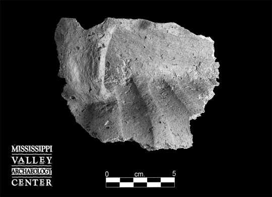
Over 9,300 pottery sherds were collected during 2008 excavations at one of the sites in the Sand Lake Archaeological District, near Onalaska, Wisconsin. Of those, nearly 160 rims and decorated body sherds were categorized into likely ceramic wares and types based on their grit or shell temper, form, and decoration. But categories created by archaeologists today to make sense of what people made in the past cannot neatly cover everything. A small group of anomalous sherds, all from different excavation units, had distinctive characteristics but defied classification into types. One grit-tempered rim (upper left) flares to a flattened lip and has a cord marked exterior surface. Another cord roughened grit-tempered sherd (upper right) thins to a rounded lip. It may fit the local Middle Woodland type Shorewood Cord Roughened. A third rim has a cord impression over a folded lip (lower right). It is grit-tempered but might also contain shell temper, a possible mix of Terminal Late Woodland and Mississippian clay preparations. One grit-tempered body sherd has parallel tool trails (lower left). It could be from a Terminal Late Woodland type vessel or from a rare grit-tempered Oneota pot.
31 notes
·
View notes
Photo
Thanks to Jim Theler for this week’s post –
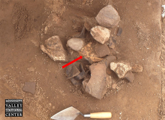
In 1987, UW-La Crosse archaeology students working at the OT site (47LC262) in La Crosse County found a dog skull in this refuse-filled pit feature (Feature 3). The skull (center of photo) was surrounded and partially overlain by Oneota pottery sherds and burned rocks. Dogs were important in Indigenous societies and served many functions, including acting as intruder alarms, consuming organic waste, carrying burdens, and being consumed under certain circumstances. Dog remains have been found at a number of late precontact Oneota sites in the La Crosse area.
46 notes
·
View notes
Photo


This woven bag was recovered from an area rockshelter. Pottery associated with the bag and the natural fibers (nettle) used to make the bag suggest an association with late precontact Oneota tradition. Perishable items such as this are rarely preserved in western Wisconsin. This one survived because of the rockshelter’s dry environment.
Link to 3D image: https://sketchfab.com/3d-models/swennes-woven-nettle-bag-native-american-7eb4f55cdaaa473f97c8b6cbeec97175
3D scan courtesy Dr. David A. Anderson, Associate Professor, UWL, Department of Archaeology & Anthropology.
11 notes
·
View notes
Photo
Thanks to Wendy Holtz-Leith and Erik Anderson for this week’s post –
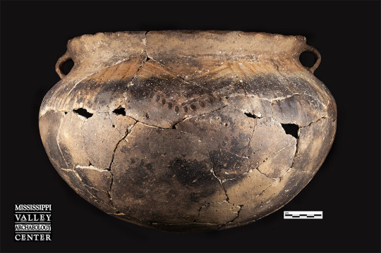
In 2012 MVAC excavated about 500 Oneota features exposed during the reconstruction of STH 35/2nd Avenue in downtown Onalaska. One unusual discovery was a nearly complete vessel found crushed in place at the base of a feature. Vessel 45, as it was later numbered, was represented by well over a hundred fragments of varying sizes.
Reconstructing a vessel is much like putting together a three-dimensional jigsaw puzzle, with quite a few pieces missing. You typically begin with the edges, which in the case of pottery, means the rim. Rim fragments from Vessel 45 were reassembled, and decorated body pieces were glued together and attached to the rim. Then came the slow process of figuring out where the undecorated pieces went. Some parts of the vessel were easier to figure out. Sherds from the base were thicker and in some cases larger, making it easier to fit them into place.
After most of the pieces were glued into larger sections, it was time to glue those sections together to form the whole vessel. This task was complicated by three things. First, some small joining fragments were missing. Second, errors in forming a vessel’s curved shape tend to creep in during the gluing and drying. Right after gluing, refitted pieces are usually placed in a sandbox to dry, and any shift can alter the curvature, making subsequent joins difficult. Third, the exterior had scorch marks or firing smudges that made its color quite variable—sometimes even adjacent sherds were completely different colors. In the end the vessel was fully reconstructed (albeit precariously), but it was left in a few very large segments because of those subtle errors from gluing.
The reconstructed vessel is very large and slightly oblong. It has a moderately high, slightly everted (outward-flaring) rim with bold finger impressions on the lip top to exterior lip. There are two handles on opposite sides of the vessel. The shoulder decoration consists of alternating panels of 12 or 13 vertical trails made with either a finger or a broad tool, and four nested chevrons with rectangular punctations below. There are four panels of nested chevrons, one under each handle and the others midway between them. The oblong rim has a diameter of 36.5 cm (14.4 inches) at the handles and ~34 cm (13.4 inches) midway between the handles. The motif is typical of the type Perrot Punctate, with very bold lip-top impressions typical of the Pammel Creek phase, A.D. 1400–1500.
#archaeology#archeology#Oneota pottery#pottery#Oneota ceramics#ceramics#Wendy Holtz-Leith#Erik Anderson#Pottery Reconstruction#Ceramic Reconstruction
17 notes
·
View notes
Photo
This shell-tempered Oneota vessel portion was found in La Crosse County in 1991. The rim flares outward and has tool impressions on the lip top. The tool was held flat, and the impressions were made at an angle rather than being perpendicular, creating a series of diagonal dashes / / / along the lip. The shoulder has blocks of diagonal tool trails made at different angles.
8 notes
·
View notes
Photo

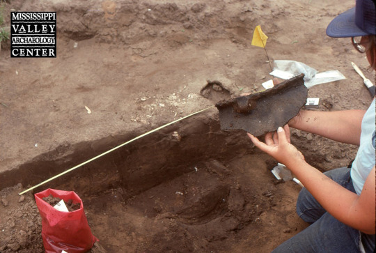
Throwback Thursday - Robert "Ernie" Boszhardt excavating an Oneota vessel at the Sanford Archaeological District in La Crosse, Wisconsin, summer 2001.
(Photo contributed by J. Theler.)
#archaeology#archeology#Sanford Archaeological District#Oneota#Pottery#Ceramics#Oneota pottery#Oneota ceramics
15 notes
·
View notes
Photo

A broken Oneota vessel fills a small pit-type feature uncovered during the 2002 excavations at the Meier Farm site (47LC432), near Onalaska, Wisconsin. This site was part of the Sand Lake site complex, where tens of acres of ridged agricultural fields were created in the moist soils of a trapped floodplain. Meier farm was one of the habitation areas associated with those fields. Most of the Sand Lake complex has since been obliterated by development.
#archaeology#archeology#Oneota#Oneota vessel#Oneota pottery#pottery#ceramics#Oneota ceramics#Meier Farm#Sand Lake
28 notes
·
View notes
Photo

This Oneota vessel was found in the early 2000s in an storage/refuse pit at the Sanford Archaeological District in La Crosse, Wisconsin. In profile the pit was flat bottomed with contracting walls. The design on the vessel fits a type called Brice Prairie Trailed that is most common in the earliest phase of the Oneota occupation of La Crosse: the Brice Prairie phase, ca. A.D. 1300–1400. The impressions on the interior of the lip are characteristic of Brice Prairie phase vessels. The shoulder looks as though it has round punctates above tool trails, but the round holes are actually the tops of “stab and drag” trails, where the tool was pushed into the top of the shoulder and then dragged downward. Charred plant remains from the pit yielded a corrected and calibrated radiocarbon date of A.D. 1387–1444 (70%, UGA 01751).
#archaeology#archeology#Oneota#Oneota pottery#Oneota vessel#Oneota ceramics#Sanford Archaeological District#ceramics#vessel#Brice Prairie
12 notes
·
View notes
Photo
Connie Arzigian lifts an Oneota rim sherd with handle from a pit feature at the Pammel Creek site (47LC61) in May 1989. This site is the type site for the Pammel Creek phase (A.D. 1400–1500) in the local Oneota sequence. The bold finger impressions on the lip of the vessel are typical for pottery from this phase. The Pammel Creek site is located south of La Crosse, Wisconsin.
14 notes
·
View notes
Photo
This Koshkonong Bold rim sherd was recovered from an Oneota circular basin, storage/garbage pit. It has lip top to exterior finger (wide) notches, giving the rim a pie-crust appearance. The vessel has a wide strap handle that tapers toward the bottom. The handle is attached below the lip and has no decoration. This rim dates to the Pammel Creek phase occupation of the site. Recovered during 2008 excavations at the Sand Lake Archaeological District, located north of La Crosse, Wisconsin.
#archaeology#archeology#Oneota#Koshkonong#$Pottery#Ceramics#Oneota pottery#Oneota ceramics#Sand Lake Archaeological District
8 notes
·
View notes
Last Seen Blogs

photodustorg
PHOTODUST

starredforlife
hold a star, kiss a monster

m4k3m3
M4K3M3

bensolosgirlf
Arabella ⚝

yourprettywitchblr
Dancing at the Funeral♡