airlinemaps
Airline Maps
Your source for airline route maps and terminal diagrams from around the world.
1381 posts
Don't wanna be here? Send us removal request.
Last Seen Blogs

fifii
إيماني

blackandsweet
put your bitch face on

ramsesja
Ramses Ja

rockerrick-555p
The Rocker Rick

solarpunk-oasis
solarpunk oasis
Video

flickr
Air Tahiti Nui map, 2007
The Air Tahiti Nui route map from a 28 October 2007 timetable.
4 notes
·
View notes
Text
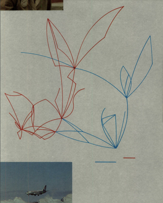
Pacific Western-Transair Merger Map, 1978
A stylised Pacific Western and Transair merger map from the former's 1978 annual report.
While we get that this map is targeted at showing shareholders Pacific Western's expanded reach after acquiring Transair — and not what cities it actually serves and from where — it still would have been nice to have some labels. Maybe just bases?
But this map does what it needs to do: show Pacific Western's growth through its acquisition of Transair. The integration was completed in 1979.
Source: Pacific Western Annual Report 1978 via McGill University Libraries
8 notes
·
View notes
Video
Independence Air Washington Dulles diagram, 2005
An Independence Air diagram of Washington Dulles International Airport from November 2005.
Independence, neé Atlantic Coast Airlines, briefly operated a hub from Dulles’ Concourses A and B in 2004 and 2005. This is one of the few diagrams of those facilities, which since have been home to a collection of international carriers, except for the ground-level A gates that continue to serve United Airlines’ hub at Dulles.
We like this map, we wish there was an overview of the airport so travelers could get a sense of where they are in the airport, but otherwise it does what’s needed.
9 notes
·
View notes
Video
MIAT route map, 2020
The MIAT Mongolian Airlines route map from a 3 March 2020 timetable.
Not the most exciting map, but it works.
2 notes
·
View notes
Text

Syrian Air map, 1984
A Syrian Air diagrammatic international lines map from 1984.
We do love a diagrammatic map. Not to say this is a perfect example, but it quite good. There are no random angles, everything is 90 degrees, and, given the size of Syrian's network, it's actually quite legible.
Source: @michirova1 on Twitter
7 notes
·
View notes
Text
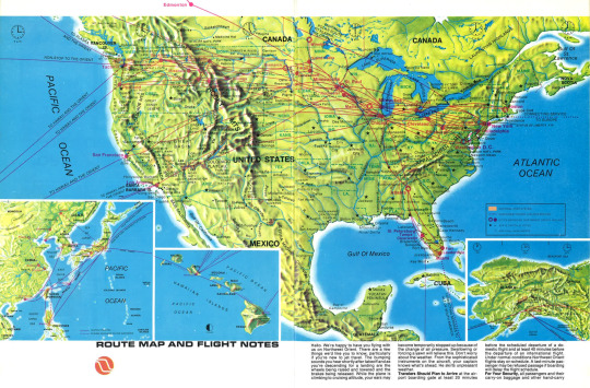
Northwest Orient routes, 1976
The Northwest Orient Airlines route map in September 1976.
Northwest clearly did not make all clean, easy-ish to read maps in the 1970s. This landscape map does what intends, shows the landscape, but as a route map it isn't that useful. The routes are difficult to follow, and the carrier's prize Asia network is minimized to an inset in the lower left hand corner.
Source: Northwest Airlines History Center
3 notes
·
View notes
Video
Allegheny cities, 1979
The Allegheny Airlines cities route map from a 1 April 1979 timetable.
This map is on the cusp of Allegheny’s name change to USAir that October. The maps are little different in style, for better or worse.
7 notes
·
View notes
Video

flickr
JetBlue Proposed Spirit Merger map, 2022
JetBlue Airways’ proposed merger with Spirit Airlines map in 2022.
A bidding war is on for Spirit with JetBlue countering the Frontier Airlines deal with its own $3.6 billion offer. This proposed merger map, while we would have loved to see routes, highlights the combined JetBlue-Spirit’s size (ie, departures) in markets across the U.S. That will be the focus of U.S. regulators as the scrutinize the proposed transaction.
1 note
·
View note
Text

Wizz Air ad map, 2005
A Wizz Air ad map from a 14 March 2005 timetable.
Source: Air, Land and Sea on Flickr
1 note
·
View note
Text

Sabena route system, 1947
The Sabena Belgian Airlines route system from a 6 June 1947 timetable.
The map shows Sabena's then new New York service via Shannon and Gander. Also, its strength to Africa, particularly the Belgian Congo, today the Democratic Republic of Congo.
Sabena shut down in 2001.
Source: Jeremy Dwyer-Lindgren
6 notes
·
View notes
Text
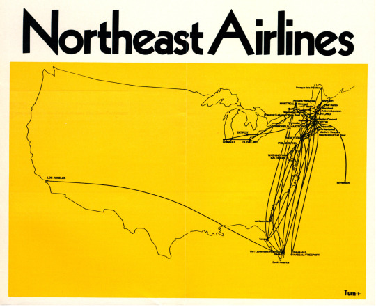
Northeast Airlines route map, 1969
The Northeast Airlines route map from a 14 September 1969 timetable.
The map shows Northeast's new nonstop service between Miami and Los Angeles that began on 1 October.
Source: George M. Foster Timetable Collection, Northwestern University's Transportation Library.
5 notes
·
View notes
Text
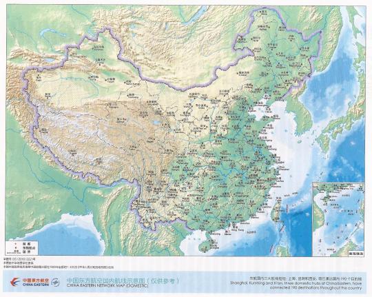
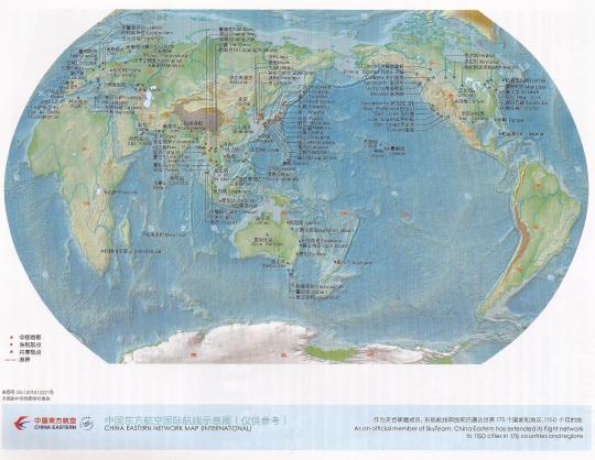
China Eastern maps, 2019
The China Eastern Airlines domestic and international network maps in March 2019.
Quite the network. We wish they were route, and not just destination, maps.
Source: Air, Land and Sea on Flickr
3 notes
·
View notes
Text

Crossair route map, 1987
The Crossair route map from a 29 March 1987 timetable.
This is a useable Crossair map, if you don't care for any geographic references. Of course, that seems the airline's preferred method of map making even after it added the outline of Europe in the 1990s.
Source: Air, Land, and Sea on Flickr
4 notes
·
View notes
Text

United Frankfurt diagram, 2001
United Airlines diagram of Frankfurt International Airport in April 2001.
Frankfurt Terminal 1, pictured above, opened 50 years ago this week in 1972.
2 notes
·
View notes
Text
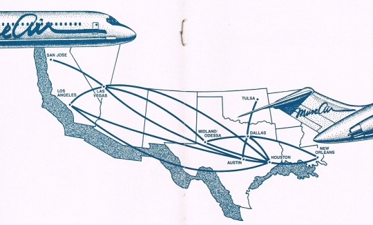
Muse Air route map, 1984
The Muse Air route map from a 1984 brochure.
This is a strong map. It gives users strong geographic anchors, while keeping its routes clear. We like the aircraft tail and nose, it adds some flair.
Muse was acquired by Southwest Airlines in 1985 and renamed TranStar Airlines. TranStar was shut down in 1987.
Source: DepartedFlights
4 notes
·
View notes
Text

Air Niugini domestic map, 1978
The Air Niugini diagrammatic domestic route map from a 29 October 1978 timetable.
Source: Air, Land, and Sea on Flickr
2 notes
·
View notes
Video
Reno Air route system, 1999
The Reno Air route system from a 1 May 1999 timetable, its final published timetable before merging with American Airlines on 30 August 1999.
5 notes
·
View notes